
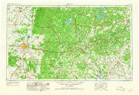
~ Abilene TX topo map, 1:250000 scale, 1 X 2 Degree, Historical, 1954, updated 1966
Abilene, Texas, USGS topographic map dated 1954.
Includes geographic coordinates (latitude and longitude). This topographic map is suitable for hiking, camping, and exploring, or framing it as a wall map.
Printed on-demand using high resolution imagery, on heavy weight and acid free paper, or alternatively on a variety of synthetic materials.
Topos available on paper, Waterproof, Poly, or Tyvek. Usually shipping rolled, unless combined with other folded maps in one order.
- Product Number: USGS-5480869
- Free digital map download (high-resolution, GeoPDF): Abilene, Texas (file size: 17 MB)
- Map Size: please refer to the dimensions of the GeoPDF map above
- Weight (paper map): ca. 55 grams
- Map Type: POD USGS Topographic Map
- Map Series: HTMC
- Map Verison: Historical
- Cell ID: 68635
- Scan ID: 106113
- Imprint Year: 1966
- Woodland Tint: Yes
- Visual Version Number: 1
- Aerial Photo Year: 1953
- Field Check Year: 1954
- Datum: Unstated
- Map Projection: Transverse Mercator
- Map published by United States Geological Survey
- Map Language: English
- Scanner Resolution: 600 dpi
- Map Cell Name: Abilene
- Grid size: 1 X 2 Degree
- Date on map: 1954
- Map Scale: 1:250000
- Geographical region: Texas, United States
Neighboring Maps:
All neighboring USGS topo maps are available for sale online at a variety of scales.
Spatial coverage:
Topo map Abilene, Texas, covers the geographical area associated the following places:
- Funston - Mankins Mill - Coalville - Purves - Atwell - Bradshaw - Lingleville - Huckabay - Bullock - Three Way - Buffalo Gap - Cross Cut - Corinth - Goldsboro - Cottonwood - Rogers - View - Tuxedo - Stith - Mangum - Avoca - Lusk - Kokomo - Brazos - Mountain Top - Santo - Bunyan - Denton - Eastland - Baird - Anson - Lueders - Eolian - Eureka - Clairette - Tiffin - Bennett - Oran - Harpersville - Beattie - Mineral Wells - Fort Phantom Hill (historical) - Lyra - Radium - Morgan Mill - Wayland - Fort Griffin - Strawn - Drasco - Patillo - Dublin - Chaney - Cisco - Elmdale - Sapoak - Jayell - Gordon Junction - Gunsight - North Abilene - Cool - Graford - Frankell - Wolters Village - Union Center - Nimrod - Eliasville - Hannibal - Coronados Camp - Eula - Metcalf Gap - Branton - Highland - Moran - Carbon - Albany - Salesville - Hodges - Breckenridge - Selden - Whitt - Wylie - Admiral - Victor - Guion - Lone Camp - Millsap - Scranton - Dothan - Sedwick - Merriman (historical) - New Salem - Stephenville - Ranger - Dudley - Berryhill - Sipe Springs - Desdemona - Acampo - Bluff Dale - Caddo
- Map Area ID: AREA3332-100-98
- Northwest corner Lat/Long code: USGSNW33-100
- Northeast corner Lat/Long code: USGSNE33-98
- Southwest corner Lat/Long code: USGSSW32-100
- Southeast corner Lat/Long code: USGSSE32-98
- Northern map edge Latitude: 33
- Southern map edge Latitude: 32
- Western map edge Longitude: -100
- Eastern map edge Longitude: -98


