
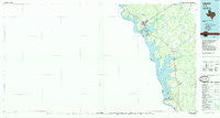
~ Zapata TX topo map, 1:100000 scale, 30 X 60 Minute, Historical, 1985, updated 1993
Zapata, Texas, USGS topographic map dated 1985.
Includes geographic coordinates (latitude and longitude). This topographic map is suitable for hiking, camping, and exploring, or framing it as a wall map.
Printed on-demand using high resolution imagery, on heavy weight and acid free paper, or alternatively on a variety of synthetic materials.
Topos available on paper, Waterproof, Poly, or Tyvek. Usually shipping rolled, unless combined with other folded maps in one order.
- Product Number: USGS-5480213
- Free digital map download (high-resolution, GeoPDF): Zapata, Texas (file size: 14 MB)
- Map Size: please refer to the dimensions of the GeoPDF map above
- Weight (paper map): ca. 55 grams
- Map Type: POD USGS Topographic Map
- Map Series: HTMC
- Map Verison: Historical
- Cell ID: 68632
- Scan ID: 123672
- Imprint Year: 1993
- Woodland Tint: Yes
- Visual Version Number: 1
- Aerial Photo Year: 1983
- Edit Year: 1985
- Datum: NAD27
- Map Projection: Universal Transverse Mercator
- Planimetric: Yes
- Map published by United States Geological Survey
- Map Language: English
- Scanner Resolution: 600 dpi
- Map Cell Name: Zapata
- Grid size: 30 X 60 Minute
- Date on map: 1985
- Map Scale: 1:100000
- Geographical region: Texas, United States
Neighboring Maps:
All neighboring USGS topo maps are available for sale online at a variety of scales.
Spatial coverage:
Topo map Zapata, Texas, covers the geographical area associated the following places:
- Four Seasons Colonia - Falcon Mesa - Falcon Village - Linda Vista - Salineño - Falcon Heights - A F Pierce Colonia - New Falcon - Jardin de San Julian Colonia - Manuel Medina Addition Colonia - Lago Halcon A Colonia - Lopeño - Falcon Estates Colonia - Buena Vista Colonia - Indio Number 1 Colonia - Morgan's Lakefront Lodge Colonia - New Falcon Colonia - Falcon Lake - Lago Halcon B Colonia - Urebeno - S Truman Phelps Colonia - Siesta Shores Section A Colonia - Falcon Lake Estates - Falconaire Colonia - Black Bass - Falcon - Zapata - H Cuellar Estates Colonia - Sunset Villa Colonia - Indio Number 2 Colonia - Las Palmas - Ranchito San Jose Colonia - Siesta Shores 3 Colonia - Flores Addition Colonia - Alejandrenas - Morales - Sanchez Colonia - Siesta Shores 1 Colonia - Cuellar Colonia - Guzman Colonia - Falcon Shores - Medina - Miguel Garza Colonia - Lago Vista Colonia - Siesta Shores - Lakefront Lodge
- Map Area ID: AREA2726.5-100-99
- Northwest corner Lat/Long code: USGSNW27-100
- Northeast corner Lat/Long code: USGSNE27-99
- Southwest corner Lat/Long code: USGSSW26.5-100
- Southeast corner Lat/Long code: USGSSE26.5-99
- Northern map edge Latitude: 27
- Southern map edge Latitude: 26.5
- Western map edge Longitude: -100
- Eastern map edge Longitude: -99


