
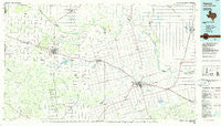
~ Vernon TX topo map, 1:100000 scale, 30 X 60 Minute, Historical, 1986, updated 1986
Vernon, Texas, USGS topographic map dated 1986.
Includes geographic coordinates (latitude and longitude). This topographic map is suitable for hiking, camping, and exploring, or framing it as a wall map.
Printed on-demand using high resolution imagery, on heavy weight and acid free paper, or alternatively on a variety of synthetic materials.
Topos available on paper, Waterproof, Poly, or Tyvek. Usually shipping rolled, unless combined with other folded maps in one order.
- Product Number: USGS-5480197
- Free digital map download (high-resolution, GeoPDF): Vernon, Texas (file size: 18 MB)
- Map Size: please refer to the dimensions of the GeoPDF map above
- Weight (paper map): ca. 55 grams
- Map Type: POD USGS Topographic Map
- Map Series: HTMC
- Map Verison: Historical
- Cell ID: 68523
- Scan ID: 123564
- Imprint Year: 1986
- Woodland Tint: Yes
- Visual Version Number: 1
- Aerial Photo Year: 1984
- Edit Year: 1986
- Datum: NAD27
- Map Projection: Universal Transverse Mercator
- Planimetric: Yes
- Map published by United States Geological Survey
- Map Language: English
- Scanner Resolution: 600 dpi
- Map Cell Name: Vernon
- Grid size: 30 X 60 Minute
- Date on map: 1986
- Map Scale: 1:100000
- Geographical region: Texas, United States
Neighboring Maps:
All neighboring USGS topo maps are available for sale online at a variety of scales.
Spatial coverage:
Topo map Vernon, Texas, covers the geographical area associated the following places:
- Davidson - Hinds - Fargo - Tolbert - Quanah - Frederick - Carnes - Eldorado - Lincoln - Margaret - Elmer - Goodlett - Williams - Oklaunion - Middleburg - Vernon - Burt - Harrold - Lockett - Vivian - Rayland - North Groesbeck - Chillicothe - Talbert Crossing - Northside - Odell - Punkin Center - Doans - Seven L Crossing - Farmers Valley - Elliott - White City - Hess - Acme (historical) - Wheatland - Willowview - Parsley Hill - Lazare - Medicine Mound
- Map Area ID: AREA34.534-100-99
- Northwest corner Lat/Long code: USGSNW34.5-100
- Northeast corner Lat/Long code: USGSNE34.5-99
- Southwest corner Lat/Long code: USGSSW34-100
- Southeast corner Lat/Long code: USGSSE34-99
- Northern map edge Latitude: 34.5
- Southern map edge Latitude: 34
- Western map edge Longitude: -100
- Eastern map edge Longitude: -99


