
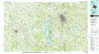
~ Tyler TX topo map, 1:100000 scale, 30 X 60 Minute, Historical, 1991, updated 1991
Tyler, Texas, USGS topographic map dated 1991.
Includes geographic coordinates (latitude and longitude). This topographic map is suitable for hiking, camping, and exploring, or framing it as a wall map.
Printed on-demand using high resolution imagery, on heavy weight and acid free paper, or alternatively on a variety of synthetic materials.
Topos available on paper, Waterproof, Poly, or Tyvek. Usually shipping rolled, unless combined with other folded maps in one order.
- Product Number: USGS-5480181
- Free digital map download (high-resolution, GeoPDF): Tyler, Texas (file size: 30 MB)
- Map Size: please refer to the dimensions of the GeoPDF map above
- Weight (paper map): ca. 55 grams
- Map Type: POD USGS Topographic Map
- Map Series: HTMC
- Map Verison: Historical
- Cell ID: 68504
- Scan ID: 123544
- Imprint Year: 1991
- Woodland Tint: Yes
- Visual Version Number: 1
- Aerial Photo Year: 1988
- Edit Year: 1991
- Datum: NAD27
- Map Projection: Universal Transverse Mercator
- Map published by United States Geological Survey
- Map Language: English
- Scanner Resolution: 600 dpi
- Map Cell Name: Tyler
- Grid size: 30 X 60 Minute
- Date on map: 1991
- Map Scale: 1:100000
- Geographical region: Texas, United States
Neighboring Maps:
All neighboring USGS topo maps are available for sale online at a variety of scales.
Spatial coverage:
Topo map Tyler, Texas, covers the geographical area associated the following places:
- Bostick - Sand Flat - Primrose - Frankston - Hideaway - Moore Station - Concord - Walnut Grove - New York - Fincastle - Stockard - Athens - New Hope - Coffee City - Bethel - Dauphin - Fosterville - Big Rock - Mount Sylvan - Gresham - Douglas - Phalba - LaRue - Cove Springs - Walton - New Chapel Hill - Antioch - Arp - Crescent Heights - Pickens - Holly Springs - Noonday - Galilee - Pine Trail Estates - Pine Grove - Reese - Pine Springs - Tyler - New Hope - Baxter - Whitton - Martins Mill - Whitehouse - Midway - Chandler - Troup - Owentown - Teaselville - Berryville - Lee Spring - Mount Selman - Blackjack - Brushy - Cherokee Landing - Opelika - Jackson - Cuney - Ben Wheeler - Pomona - Friendship - Hide-A-Way Lake - Union Hill - Poynor - Flint - Salem - Griffin - Tundra - Omen - Sumer Hill - Copeland - Murchison - Mixon - Carroll - Evelyn - Bullard - Cross Roads - Shady Oaks - Swan - Denman Crossroads - Emmaus - Bascom - Wood Springs - Mars - Dogwood City - Midway - Blackjack - Edom - Leagueville - Gould - Brownsboro - New Harmony - Elberta - Shady Grove - Larissa - Thedford - Antioch - Virginia Hill - Winona - Sinclair City - Starrville
- Map Area ID: AREA32.532-96-95
- Northwest corner Lat/Long code: USGSNW32.5-96
- Northeast corner Lat/Long code: USGSNE32.5-95
- Southwest corner Lat/Long code: USGSSW32-96
- Southeast corner Lat/Long code: USGSSE32-95
- Northern map edge Latitude: 32.5
- Southern map edge Latitude: 32
- Western map edge Longitude: -96
- Eastern map edge Longitude: -95


