
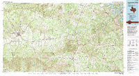
~ Pedernales River TX topo map, 1:100000 scale, 30 X 60 Minute, Historical, 1985, updated 1992
Pedernales River, Texas, USGS topographic map dated 1985.
Includes geographic coordinates (latitude and longitude). This topographic map is suitable for hiking, camping, and exploring, or framing it as a wall map.
Printed on-demand using high resolution imagery, on heavy weight and acid free paper, or alternatively on a variety of synthetic materials.
Topos available on paper, Waterproof, Poly, or Tyvek. Usually shipping rolled, unless combined with other folded maps in one order.
- Product Number: USGS-5480039
- Free digital map download (high-resolution, GeoPDF): Pedernales River, Texas (file size: 34 MB)
- Map Size: please refer to the dimensions of the GeoPDF map above
- Weight (paper map): ca. 55 grams
- Map Type: POD USGS Topographic Map
- Map Series: HTMC
- Map Verison: Historical
- Cell ID: 68132
- Scan ID: 117477
- Imprint Year: 1992
- Woodland Tint: Yes
- Visual Version Number: 1
- Aerial Photo Year: 1981
- Edit Year: 1985
- Datum: NAD27
- Map Projection: Universal Transverse Mercator
- Map published by United States Geological Survey
- Map Language: English
- Scanner Resolution: 600 dpi
- Map Cell Name: Pedernales River
- Grid size: 30 X 60 Minute
- Date on map: 1985
- Map Scale: 1:100000
- Geographical region: Texas, United States
Neighboring Maps:
All neighboring USGS topo maps are available for sale online at a variety of scales.
Spatial coverage:
Topo map Pedernales River, Texas, covers the geographical area associated the following places:
- Hammetts Crossing - Shovel Mountain - Sandy - Rocky Creek - Flugrath - Crabapple - Flugrath - Dripping Springs - Cain City - Blanco - Payton - Luckenbach - Briarcliff - Henly - Johnson City - Woodcreek - Westbrook (historical) - Fredericksburg - Stonewall - Bankersmith - Spicewood - Blowout - Cypress Mill - Cherry Mountain - Cypress Creek - Shovel Mountain - Willow City - Pleasant Valley Crossing - Mount Gainor - Hye - Lindendale - Rocky Hill - Round Mountain - Albert - Hilltop - Eckert - Post Oak - Grapetown - Driftwood - Blumenthal - Twin Sisters - Fitzhugh
- Map Area ID: AREA30.530-99-98
- Northwest corner Lat/Long code: USGSNW30.5-99
- Northeast corner Lat/Long code: USGSNE30.5-98
- Southwest corner Lat/Long code: USGSSW30-99
- Southeast corner Lat/Long code: USGSSE30-98
- Northern map edge Latitude: 30.5
- Southern map edge Latitude: 30
- Western map edge Longitude: -99
- Eastern map edge Longitude: -98


