
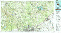
~ New Braunfels TX topo map, 1:100000 scale, 30 X 60 Minute, Historical, 1992, updated 1992
New Braunfels, Texas, USGS topographic map dated 1992.
Includes geographic coordinates (latitude and longitude). This topographic map is suitable for hiking, camping, and exploring, or framing it as a wall map.
Printed on-demand using high resolution imagery, on heavy weight and acid free paper, or alternatively on a variety of synthetic materials.
Topos available on paper, Waterproof, Poly, or Tyvek. Usually shipping rolled, unless combined with other folded maps in one order.
- Product Number: USGS-5480015
- Free digital map download (high-resolution, GeoPDF): New Braunfels, Texas (file size: 30 MB)
- Map Size: please refer to the dimensions of the GeoPDF map above
- Weight (paper map): ca. 55 grams
- Map Type: POD USGS Topographic Map
- Map Series: HTMC
- Map Verison: Historical
- Cell ID: 68039
- Scan ID: 117357
- Imprint Year: 1992
- Woodland Tint: Yes
- Visual Version Number: 2
- Photo Revision Year: 1992
- Aerial Photo Year: 1987
- Datum: NAD27
- Map Projection: Universal Transverse Mercator
- Map published by United States Geological Survey
- Map Language: English
- Scanner Resolution: 600 dpi
- Map Cell Name: New Braunfels
- Grid size: 30 X 60 Minute
- Date on map: 1992
- Map Scale: 1:100000
- Geographical region: Texas, United States
Neighboring Maps:
All neighboring USGS topo maps are available for sale online at a variety of scales.
Spatial coverage:
Topo map New Braunfels, Texas, covers the geographical area associated the following places:
- Lake Dunlap - Helotes - Live Oak - Bergheim - Sattler - Freiheit - Muehlsville - Lakehills - Ogden - Santa Clara - Shavano Park - Van Raub - Honey Creek - San Geronimo - Buffalo Springs (historical) - Oak Cliff Acres - Corbyn - Hunter - Fair Oaks Ranch - Bulverde South (historical) - Pipe Creek - Lake Medina Highlands - Windcrest - Sisterdale - Garden Ridge - Dominion - Anhalt - Kendalia - Camp Willow - Zipp - Scenic Oaks - Hollywood Park - First Crossing - Clear Springs - Cranes Mill - Second Crossing - Northcliff - Welfare - Cibolo - Canyon Lake - Landa Park Highlands - Comfort - McQueeney - Fischer - Leon Springs - Schertz - Cloptins Crossing - English Crossing - Robards - Nolte - Solms - Comal - Bandera Falls - Wetmore - Dittlinger - Converse - Lake Hills - Third Crossing - Luxello - Lakehills - Hill Country Village - Royal Forest - Canyon Lake Forest - Fourth Crossing - Mico - Ammans Crossing - Airport City - Universal City - Haeckerville - Barbarosa - Oberly Crossing - Timberwood Park - Specht Store - Valley View - Silver Hills - Bulverde East (historical) - Longhorn - Bulverde - Beckmann - Preiss Heights - Kreutzberg - Smithson Valley - Pioneer Town - Canyon Springs - Boerne - Nelson City - Startzville - Walnut Grove - Grey Forest - Gruene - Westhaven - Thorn Hill - Marion - Schumannsville - Castle Hills - Jentsch Acres - North Loop - Oakland Estates - Bracken - Bulverde West (historical)
- Map Area ID: AREA3029.5-99-98
- Northwest corner Lat/Long code: USGSNW30-99
- Northeast corner Lat/Long code: USGSNE30-98
- Southwest corner Lat/Long code: USGSSW29.5-99
- Southeast corner Lat/Long code: USGSSE29.5-98
- Northern map edge Latitude: 30
- Southern map edge Latitude: 29.5
- Western map edge Longitude: -99
- Eastern map edge Longitude: -98


