
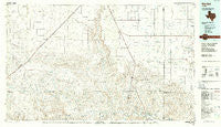
~ Hartley TX topo map, 1:100000 scale, 30 X 60 Minute, Historical, 1985, updated 1988
Hartley, Texas, USGS topographic map dated 1985.
Includes geographic coordinates (latitude and longitude). This topographic map is suitable for hiking, camping, and exploring, or framing it as a wall map.
Printed on-demand using high resolution imagery, on heavy weight and acid free paper, or alternatively on a variety of synthetic materials.
Topos available on paper, Waterproof, Poly, or Tyvek. Usually shipping rolled, unless combined with other folded maps in one order.
- Product Number: USGS-5479891
- Free digital map download (high-resolution, GeoPDF): Hartley, Texas (file size: 21 MB)
- Map Size: please refer to the dimensions of the GeoPDF map above
- Weight (paper map): ca. 55 grams
- Map Type: POD USGS Topographic Map
- Map Series: HTMC
- Map Verison: Historical
- Cell ID: 67644
- Scan ID: 117805
- Imprint Year: 1988
- Woodland Tint: Yes
- Visual Version Number: 1
- Edit Year: 1985
- Datum: NAD27
- Map Projection: Universal Transverse Mercator
- Map published by United States Geological Survey
- Map Language: English
- Scanner Resolution: 600 dpi
- Map Cell Name: Hartley
- Grid size: 30 X 60 Minute
- Date on map: 1985
- Map Scale: 1:100000
- Geographical region: Texas, United States
Neighboring Maps:
All neighboring USGS topo maps are available for sale online at a variety of scales.
Spatial coverage:
Topo map Hartley, Texas, covers the geographical area associated the following places:
- Stallwitz Lake - Hartley - Romero - Boys Ranch - Knoblaw - Murdo - Hollicott Crossing - Tascosa - Partwood Crossing - Bautista - Rehm - Corner Windmill - Middle Water - Channing - Old Tascosa (historical) - Middlewell - King - Old Farm Crossing - Strip Crossing - Twin Mill
- Map Area ID: AREA3635.5-103-102
- Northwest corner Lat/Long code: USGSNW36-103
- Northeast corner Lat/Long code: USGSNE36-102
- Southwest corner Lat/Long code: USGSSW35.5-103
- Southeast corner Lat/Long code: USGSSE35.5-102
- Northern map edge Latitude: 36
- Southern map edge Latitude: 35.5
- Western map edge Longitude: -103
- Eastern map edge Longitude: -102


