
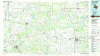
~ Gainesville TX topo map, 1:100000 scale, 30 X 60 Minute, Historical, 1985, updated 1985
Gainesville, Texas, USGS topographic map dated 1985.
Includes geographic coordinates (latitude and longitude). This topographic map is suitable for hiking, camping, and exploring, or framing it as a wall map.
Printed on-demand using high resolution imagery, on heavy weight and acid free paper, or alternatively on a variety of synthetic materials.
Topos available on paper, Waterproof, Poly, or Tyvek. Usually shipping rolled, unless combined with other folded maps in one order.
- Product Number: USGS-5479867
- Free digital map download (high-resolution, GeoPDF): Gainesville, Texas (file size: 20 MB)
- Map Size: please refer to the dimensions of the GeoPDF map above
- Weight (paper map): ca. 55 grams
- Map Type: POD USGS Topographic Map
- Map Series: HTMC
- Map Verison: Historical
- Cell ID: 67556
- Scan ID: 122339
- Imprint Year: 1985
- Woodland Tint: Yes
- Visual Version Number: 1
- Aerial Photo Year: 1981
- Edit Year: 1985
- Datum: NAD27
- Map Projection: Universal Transverse Mercator
- Planimetric: Yes
- Map published by United States Geological Survey
- Map Language: English
- Scanner Resolution: 600 dpi
- Map Cell Name: Gainesville
- Grid size: 30 X 60 Minute
- Date on map: 1985
- Map Scale: 1:100000
- Geographical region: Texas, United States
Neighboring Maps:
All neighboring USGS topo maps are available for sale online at a variety of scales.
Spatial coverage:
Topo map Gainesville, Texas, covers the geographical area associated the following places:
- Custer City - McDonald - Dye - Dry Valley - Leon - Nocona - Thackerville - Stanfield - Valley View - Ringgold - Freemound - Hardy - Hood - Jimtown - Terral - Nocona Hills - Marietta - Sivells Bend - Oak Ridge - Stoneburg - Woodbine - Walnut Bend - Rubottom - Muenster - Hynds City - Fruitland - Cook - Bowie - Belcherville - Lake Kiowa - Callisburg - Mallard - Bonita - Turner - Corinth - Illinois Bend - Pike - Myra - Forestburg - Marysville - Capps Corner - Belleville - Bomar - Coesfield - Spanish Fort - Fleetwood - Salona - Saint Jo - Montague - Gainesville - Petersburg - Burneyville - Burns City - Oscar - Courtney - Eastman - Rowland - Gladys - Dunbar - Bulcher - Lindsay
- Map Area ID: AREA3433.5-98-97
- Northwest corner Lat/Long code: USGSNW34-98
- Northeast corner Lat/Long code: USGSNE34-97
- Southwest corner Lat/Long code: USGSSW33.5-98
- Southeast corner Lat/Long code: USGSSE33.5-97
- Northern map edge Latitude: 34
- Southern map edge Latitude: 33.5
- Western map edge Longitude: -98
- Eastern map edge Longitude: -97


