
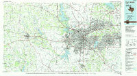
~ Fort Worth TX topo map, 1:100000 scale, 30 X 60 Minute, Historical, 1985, updated 1985
Fort Worth, Texas, USGS topographic map dated 1985.
Includes geographic coordinates (latitude and longitude). This topographic map is suitable for hiking, camping, and exploring, or framing it as a wall map.
Printed on-demand using high resolution imagery, on heavy weight and acid free paper, or alternatively on a variety of synthetic materials.
Topos available on paper, Waterproof, Poly, or Tyvek. Usually shipping rolled, unless combined with other folded maps in one order.
- Product Number: USGS-5479863
- Free digital map download (high-resolution, GeoPDF): Fort Worth, Texas (file size: 25 MB)
- Map Size: please refer to the dimensions of the GeoPDF map above
- Weight (paper map): ca. 55 grams
- Map Type: POD USGS Topographic Map
- Map Series: HTMC
- Map Verison: Historical
- Cell ID: 67543
- Scan ID: 122319
- Imprint Year: 1985
- Woodland Tint: Yes
- Visual Version Number: 1
- Aerial Photo Year: 1981
- Edit Year: 1985
- Datum: NAD27
- Map Projection: Universal Transverse Mercator
- Planimetric: Yes
- Map published by United States Geological Survey
- Map Language: English
- Scanner Resolution: 600 dpi
- Map Cell Name: Fort Worth
- Grid size: 30 X 60 Minute
- Date on map: 1985
- Map Scale: 1:100000
- Geographical region: Texas, United States
Neighboring Maps:
All neighboring USGS topo maps are available for sale online at a variety of scales.
Spatial coverage:
Topo map Fort Worth, Texas, covers the geographical area associated the following places:
- Southlake - Castle Hill Estate - Keller - Greenwood - Reno - Annetta South - Shady Grove - Hudson Oaks - Handley - Allison - River Oaks - Bransford - Springtown - Ederville - Dicey - Haslet - Melody Hills - Peaster - Azle - Center Point - Wampler - Preble - Poolville - Fairview - Lillian - Agnes - Arlington - Tin Top - Blue Mound - Stephens Crossing - Westlake - Adell - Lemley - Earls - Saginaw - Willow Park - Lytle - Lakeview - Westover Hills - Johnsons Station - Lake Crest Estates - Western Lake - Old Union - Bethel - Benbrook - Pine Tree Estates Number 2 - Sanctuary - Bedford - Garner - Kennedale - Lake Forest - Dennis - Saint Francis Village - Sabathany - Iona - Brock - Highland Addition - Briar - Briaroaks - Cresson - Weatherford - Alta Vista Mobile Home Park - Westland - Wheatland - Cross Timber - Center Mill - Primrose - Euless - Plover - Pelican Bay - Colleyville - Garden Acres - Maxwell Crossing - Smithfield - Coppell - Eagle Acres - Sublett - Baker - Advance - Fort Worth - Peden - Tate Springs - Minters Chapel - Belt Junction - Forest Hill - Lake Worth - Wright - Pantego - Newark Beach - Florence Hill - Fox - Boss - Britton - Trophy Club - La Junta - Estelle - Tarrant - Valley Ridge - Rendon - Bisbee
- Map Area ID: AREA3332.5-98-97
- Northwest corner Lat/Long code: USGSNW33-98
- Northeast corner Lat/Long code: USGSNE33-97
- Southwest corner Lat/Long code: USGSSW32.5-98
- Southeast corner Lat/Long code: USGSSE32.5-97
- Northern map edge Latitude: 33
- Southern map edge Latitude: 32.5
- Western map edge Longitude: -98
- Eastern map edge Longitude: -97


