
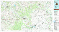
~ Eagle Lake TX topo map, 1:100000 scale, 30 X 60 Minute, Historical, 1985, updated 1992
Eagle Lake, Texas, USGS topographic map dated 1985.
Includes geographic coordinates (latitude and longitude). This topographic map is suitable for hiking, camping, and exploring, or framing it as a wall map.
Printed on-demand using high resolution imagery, on heavy weight and acid free paper, or alternatively on a variety of synthetic materials.
Topos available on paper, Waterproof, Poly, or Tyvek. Usually shipping rolled, unless combined with other folded maps in one order.
- Product Number: USGS-5479835
- Free digital map download (high-resolution, GeoPDF): Eagle Lake, Texas (file size: 24 MB)
- Map Size: please refer to the dimensions of the GeoPDF map above
- Weight (paper map): ca. 55 grams
- Map Type: POD USGS Topographic Map
- Map Series: HTMC
- Map Verison: Historical
- Cell ID: 67449
- Scan ID: 122279
- Imprint Year: 1992
- Woodland Tint: Yes
- Visual Version Number: 1
- Aerial Photo Year: 1981
- Edit Year: 1985
- Datum: NAD27
- Map Projection: Universal Transverse Mercator
- Map published by United States Geological Survey
- Map Language: English
- Scanner Resolution: 600 dpi
- Map Cell Name: Eagle Lake
- Grid size: 30 X 60 Minute
- Date on map: 1985
- Map Scale: 1:100000
- Geographical region: Texas, United States
Neighboring Maps:
All neighboring USGS topo maps are available for sale online at a variety of scales.
Spatial coverage:
Topo map Eagle Lake, Texas, covers the geographical area associated the following places:
- Hostyn - Rockhouse - New Bremen - Rexville - Peters - Lafitte - O'Quinn - Ramsey - Clemons - Rek Hill - Burleigh - Freyburg - Holman - High Hill - Krebsville - Shaws Bend - Sunny Side - Mullins Prairie - Dubina - Rabbs Prairie - Rock House - Rayner Junction - Joiner - Cozy Corner - Breslau - Park - Prairie Valley - Weimar - Ellinger - Oldenburg - Ammannsville - Nelsonville - Monaville - Columbus - Nottawa - Hillcrest - Eagle Lake - Halsted - Saint John - Post Oak Point - Pisek - Borden - Swiss Alp - La Grange - Hackberry - Wallis - Laban - Glidden - Lakeside - Kinkler - Lissie - Beard - Bellville - Willow Springs - New Bielau - Alleyton - Brazos Country - Altair - Millheim - Hoefer - Rock Island - New Ulm - Plum - Gleckler - Chesterville - Macedonia - Fayetteville - Industry - Rutersville - San Felipe - Helms - Roznov - Wendt - Cat Spring - Tamberg - Atascosito Crossing (historical) - Schulenburg - Bernardo - Lone Oak - Oakland - Appelt Hill - Frydek - East Bernard - Moravia - Gay Hill - Mentz - Gwinns Crossing (historical) - Sealy - Frelsburg
- Map Area ID: AREA3029.5-97-96
- Northwest corner Lat/Long code: USGSNW30-97
- Northeast corner Lat/Long code: USGSNE30-96
- Southwest corner Lat/Long code: USGSSW29.5-97
- Southeast corner Lat/Long code: USGSSE29.5-96
- Northern map edge Latitude: 30
- Southern map edge Latitude: 29.5
- Western map edge Longitude: -97
- Eastern map edge Longitude: -96


