
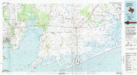
~ Anahuac TX topo map, 1:100000 scale, 30 X 60 Minute, Historical, 1983, updated 1983
Anahuac, Texas, USGS topographic map dated 1983.
Includes geographic coordinates (latitude and longitude). This topographic map is suitable for hiking, camping, and exploring, or framing it as a wall map.
Printed on-demand using high resolution imagery, on heavy weight and acid free paper, or alternatively on a variety of synthetic materials.
Topos available on paper, Waterproof, Poly, or Tyvek. Usually shipping rolled, unless combined with other folded maps in one order.
- Product Number: USGS-5479687
- Free digital map download (high-resolution, GeoPDF): Anahuac, Texas (file size: 26 MB)
- Map Size: please refer to the dimensions of the GeoPDF map above
- Weight (paper map): ca. 55 grams
- Map Type: POD USGS Topographic Map
- Map Series: HTMC
- Map Verison: Historical
- Cell ID: 67047
- Scan ID: 108166
- Imprint Year: 1983
- Woodland Tint: Yes
- Visual Version Number: 2
- Aerial Photo Year: 1982
- Edit Year: 1983
- Datum: NAD27
- Map Projection: Universal Transverse Mercator
- Map published by United States Geological Survey
- Map Language: English
- Scanner Resolution: 600 dpi
- Map Cell Name: Anahuac
- Grid size: 30 X 60 Minute
- Date on map: 1983
- Map Scale: 1:100000
- Geographical region: Texas, United States
Neighboring Maps:
All neighboring USGS topo maps are available for sale online at a variety of scales.
Spatial coverage:
Topo map Anahuac, Texas, covers the geographical area associated the following places:
- Timber Lake Estates - Tivett - Port Acres - Double Bayou - Turtle Bayou - Bacliff - Clifton Beach - Winnie - Allenbrook - Anahuac - Beach City - Wallisville - San Jacinto Place - Galloway - Hillebrandt - Pelly - Country Club Cove - Smith Point - Roseland Manor - Chase Park - El Jardin Del Mar - Country Club Oaks - Shiloh - Eldon - Fannett - Rollover - Monroe City - Hamshire - Abshier Settlement - Lovell Lake - Morgans Point - Beauxart Gardens - Cove - Cheek - Old River Community - Country Club Estates - Mont Belvieu - Ginger Green - Figridge - Gilchrist - Surf Oaks - Central Gardens - Hebert - High Island - Chaparral Village - Sea Breeze - Esperson - Hankamer - Stowell - Viterbo - Morey - Oak Island - Old River-Winfree - Taylor Landing - Moss Bluff - Cottonwood - Eminence - Baytown - Cedar Bayou - South Dayton - Red Bluff - Sheeks - Country Club Gardens - Lucas - Quail Hollow - La Belle
- Map Area ID: AREA3029.5-95-94
- Northwest corner Lat/Long code: USGSNW30-95
- Northeast corner Lat/Long code: USGSNE30-94
- Southwest corner Lat/Long code: USGSSW29.5-95
- Southeast corner Lat/Long code: USGSSE29.5-94
- Northern map edge Latitude: 30
- Southern map edge Latitude: 29.5
- Western map edge Longitude: -95
- Eastern map edge Longitude: -94


