
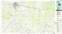
~ Abilene TX topo map, 1:100000 scale, 30 X 60 Minute, Historical, 1985, updated 1986
Abilene, Texas, USGS topographic map dated 1985.
Includes geographic coordinates (latitude and longitude). This topographic map is suitable for hiking, camping, and exploring, or framing it as a wall map.
Printed on-demand using high resolution imagery, on heavy weight and acid free paper, or alternatively on a variety of synthetic materials.
Topos available on paper, Waterproof, Poly, or Tyvek. Usually shipping rolled, unless combined with other folded maps in one order.
- Product Number: USGS-5479667
- Free digital map download (high-resolution, GeoPDF): Abilene, Texas (file size: 20 MB)
- Map Size: please refer to the dimensions of the GeoPDF map above
- Weight (paper map): ca. 55 grams
- Map Type: POD USGS Topographic Map
- Map Series: HTMC
- Map Verison: Historical
- Cell ID: 67009
- Scan ID: 121914
- Imprint Year: 1986
- Woodland Tint: Yes
- Visual Version Number: 1
- Aerial Photo Year: 1984
- Edit Year: 1985
- Datum: NAD27
- Map Projection: Universal Transverse Mercator
- Planimetric: Yes
- Map published by United States Geological Survey
- Map Language: English
- Scanner Resolution: 600 dpi
- Map Cell Name: Abilene
- Grid size: 30 X 60 Minute
- Date on map: 1985
- Map Scale: 1:100000
- Geographical region: Texas, United States
Neighboring Maps:
All neighboring USGS topo maps are available for sale online at a variety of scales.
Spatial coverage:
Topo map Abilene, Texas, covers the geographical area associated the following places:
- Guion - Mount Pleasant - Baird - Buffalo Gap - Denton - Wylie - Rowden - Admiral - Webbville - Dudley - Williams - Pioneer - Cross Cut - Ovalo - Belle Plain - Nimrod - Pueblo - Atwell - Bradshaw - Rogers - Elmdale - Goldsboro - Abilene - Sabanno - Potosi - View - Tuscola - Mitchell - Putnam - Impact - Lawn - Oplin - Cross Plains - Cozart - Tye - Clyde - Drasco - Caps - Scranton - Jayell - Cottonwood - Eula
- Map Area ID: AREA32.532-100-99
- Northwest corner Lat/Long code: USGSNW32.5-100
- Northeast corner Lat/Long code: USGSNE32.5-99
- Southwest corner Lat/Long code: USGSSW32-100
- Southeast corner Lat/Long code: USGSSE32-99
- Northern map edge Latitude: 32.5
- Southern map edge Latitude: 32
- Western map edge Longitude: -100
- Eastern map edge Longitude: -99


