
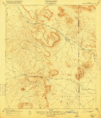
~ Jordan Gap TX topo map, 1:62500 scale, 15 X 15 Minute, Historical, 1918
Jordan Gap, Texas, USGS topographic map dated 1918.
Includes geographic coordinates (latitude and longitude). This topographic map is suitable for hiking, camping, and exploring, or framing it as a wall map.
Printed on-demand using high resolution imagery, on heavy weight and acid free paper, or alternatively on a variety of synthetic materials.
Topos available on paper, Waterproof, Poly, or Tyvek. Usually shipping rolled, unless combined with other folded maps in one order.
- Product Number: USGS-5478687
- Free digital map download (high-resolution, GeoPDF): Jordan Gap, Texas (file size: 7 MB)
- Map Size: please refer to the dimensions of the GeoPDF map above
- Weight (paper map): ca. 55 grams
- Map Type: POD USGS Topographic Map
- Map Series: HTMC
- Map Verison: Historical
- Cell ID: 55909
- Scan ID: 128440
- Visual Version Number: 1
- Survey Year: 1917
- Datum: Unstated
- Map Projection: Unstated
- Map published by United States Army Corps of Engineers
- Map published by United States Department of War
- Map Language: English
- Scanner Resolution: 600 dpi
- Map Cell Name: Jordan Gap
- Grid size: 15 X 15 Minute
- Date on map: 1918
- Map Scale: 1:62500
- Geographical region: Texas, United States
Neighboring Maps:
All neighboring USGS topo maps are available for sale online at a variety of scales.
Spatial coverage:
Topo map Jordan Gap, Texas, covers the geographical area associated the following places:
- Puerto Potrillo - McKinney Mountain - Hat Mountain - Turney Peak - Whirlwind Mesa - Antelope Mesa - Paradise Valley - Jordan Gap - Cerro Boludo - Hackberry Draw - Gemelo Mesa - Church Mountain - Paradise Draw - Housetop Mountain - Red Hill - San Jacinto Mountain - Perdiz
- Map Area ID: AREA3029.75-104-103.75
- Northwest corner Lat/Long code: USGSNW30-104
- Northeast corner Lat/Long code: USGSNE30-103.75
- Southwest corner Lat/Long code: USGSSW29.75-104
- Southeast corner Lat/Long code: USGSSE29.75-103.75
- Northern map edge Latitude: 30
- Southern map edge Latitude: 29.75
- Western map edge Longitude: -104
- Eastern map edge Longitude: -103.75


