
~ West of Eagle TX topo map, 1:31680 scale, 7.5 X 7.5 Minute, Historical, 1943
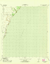
West of Eagle, Texas, USGS topographic map dated 1943.
Includes geographic coordinates (latitude and longitude). This topographic map is suitable for hiking, camping, and exploring, or framing it as a wall map.
Printed on-demand using high resolution imagery, on heavy weight and acid free paper, or alternatively on a variety of synthetic materials.
Topos available on paper, Waterproof, Poly, or Tyvek. Usually shipping rolled, unless combined with other folded maps in one order.
- Product Number: USGS-5477919
- Free digital map download (high-resolution, GeoPDF): West of Eagle, Texas (file size: 4 MB)
- Map Size: please refer to the dimensions of the GeoPDF map above
- Weight (paper map): ca. 55 grams
- Map Type: POD USGS Topographic Map
- Map Series: HTMC
- Map Verison: Historical
- Cell ID: 46285
- Scan ID: 117063
- Woodland Tint: Yes
- Visual Version Number: 1
- Aerial Photo Year: 1942
- Survey Year: 1943
- Datum: NAD27
- Map Projection: Polyconic
- Map published by United States Army Corps of Engineers
- Map published by United States Department of War
- Map Language: English
- Scanner Resolution: 600 dpi
- Map Cell Name: Umbrella Point
- Grid size: 7.5 X 7.5 Minute
- Date on map: 1943
- Map Scale: 1:31680
- Geographical region: Texas, United States
Neighboring Maps:
All neighboring USGS topo maps are available for sale online at a variety of scales.
Spatial coverage:
Topo map West of Eagle, Texas, covers the geographical area associated the following places:
- Fisher Cemetery - Point Barrow - Optimist Camp - Trinity Bay Church - Tri-City Beach Mission - McCollum County Park - Fishers Reef Oil Field - City of Beach City - Fisher Shoals - Beach City Volunteer Fire Department - Cedar Gully - Umbrella Point - Trinity Bay Oil Field - Camp Trinity Bay - Umbrella Point Oil Field - Barrow Cemetery - Beach City City Hall - Trinity Bay
- Map Area ID: AREA29.7529.625-94.875-94.75
- Northwest corner Lat/Long code: USGSNW29.75-94.875
- Northeast corner Lat/Long code: USGSNE29.75-94.75
- Southwest corner Lat/Long code: USGSSW29.625-94.875
- Southeast corner Lat/Long code: USGSSE29.625-94.75
- Northern map edge Latitude: 29.75
- Southern map edge Latitude: 29.625
- Western map edge Longitude: -94.875
- Eastern map edge Longitude: -94.75


