
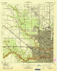
~ Houston Heights TX topo map, 1:31680 scale, 7.5 X 7.5 Minute, Historical, 1946
Houston Heights, Texas, USGS topographic map dated 1946.
Includes geographic coordinates (latitude and longitude). This topographic map is suitable for hiking, camping, and exploring, or framing it as a wall map.
Printed on-demand using high resolution imagery, on heavy weight and acid free paper, or alternatively on a variety of synthetic materials.
Topos available on paper, Waterproof, Poly, or Tyvek. Usually shipping rolled, unless combined with other folded maps in one order.
- Product Number: USGS-5477695
- Free digital map download (high-resolution, GeoPDF): Houston Heights, Texas (file size: 7 MB)
- Map Size: please refer to the dimensions of the GeoPDF map above
- Weight (paper map): ca. 55 grams
- Map Type: POD USGS Topographic Map
- Map Series: HTMC
- Map Verison: Historical
- Cell ID: 21238
- Scan ID: 110845
- Woodland Tint: Yes
- Visual Version Number: 1
- Datum: NAD27
- Map Projection: Polyconic
- Map published by United States Army Corps of Engineers
- Map published by United States Department of War
- Map Language: English
- Scanner Resolution: 600 dpi
- Map Cell Name: Houston Heights
- Grid size: 7.5 X 7.5 Minute
- Date on map: 1946
- Map Scale: 1:31680
- Geographical region: Texas, United States
Neighboring Maps:
All neighboring USGS topo maps are available for sale online at a variety of scales.
Spatial coverage:
Topo map Houston Heights, Texas, covers the geographical area associated the following places:
- Forest West Shopping Center - Holly Park - Shady Acres - Forest Pine - Oak Forest - Graceland Terrace - Spring Oaks - Inwood Pines - Woodland Heights - Timber Grove Manor - Rosslyn - Chateau Forest - Westview Terrace - Glenburnie - Stude - Pinemont Plaza - Eureka Acres - Central Park Northwest - Fairway Park - Melrose Gardens - Pine Terrace - Highland Heights - Ridgecrest - Stone Heights - Antoine Forest Estates - Houston Heights - Sheraton Oaks - Highland Acres Homes - Candlelight Forest West - Oaks of Inwood - Magnum Manor - Springdale - Hilshire Village - Arbor Oaks - Hunters Creek Village - Garden Oaks - Monarch Oaks - Candlelight Oaks Village - Candlelight - Brookhollow - Bayou Bend - Brook Smith
- Map Area ID: AREA29.87529.75-95.5-95.375
- Northwest corner Lat/Long code: USGSNW29.875-95.5
- Northeast corner Lat/Long code: USGSNE29.875-95.375
- Southwest corner Lat/Long code: USGSSW29.75-95.5
- Southeast corner Lat/Long code: USGSSE29.75-95.375
- Northern map edge Latitude: 29.875
- Southern map edge Latitude: 29.75
- Western map edge Longitude: -95.5
- Eastern map edge Longitude: -95.375


