
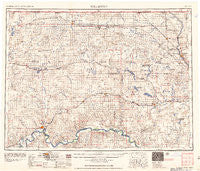
~ Williston ND topo map, 1:250000 scale, 1 X 2 Degree, Historical, 1957, updated 1957
Williston, North Dakota, USGS topographic map dated 1957.
Includes geographic coordinates (latitude and longitude). This topographic map is suitable for hiking, camping, and exploring, or framing it as a wall map.
Printed on-demand using high resolution imagery, on heavy weight and acid free paper, or alternatively on a variety of synthetic materials.
Topos available on paper, Waterproof, Poly, or Tyvek. Usually shipping rolled, unless combined with other folded maps in one order.
- Product Number: USGS-5473811
- Free digital map download (high-resolution, GeoPDF): Williston, North Dakota (file size: 17 MB)
- Map Size: please refer to the dimensions of the GeoPDF map above
- Weight (paper map): ca. 55 grams
- Map Type: POD USGS Topographic Map
- Map Series: HTMC
- Map Verison: Historical
- Cell ID: 69100
- Scan ID: 285547
- Imprint Year: 1957
- Woodland Tint: Yes
- Aerial Photo Year: 1952
- Field Check Year: 1953
- Datum: Unstated
- Map Projection: Transverse Mercator
- Map published by United States Army Corps of Engineers
- Map published by United States Army
- Map Language: English
- Scanner Resolution: 600 dpi
- Map Cell Name: Williston
- Grid size: 1 X 2 Degree
- Date on map: 1957
- Map Scale: 1:250000
- Geographical region: North Dakota, United States
Neighboring Maps:
All neighboring USGS topo maps are available for sale online at a variety of scales.
Spatial coverage:
Topo map Williston, North Dakota, covers the geographical area associated the following places:
- Kermit - Marmon - Blaisdell - Atcoal - Noonan - Kincaid - Nine Mile Corner - Stanley - Temple - West Bonetraill - Williston - Coulee - Larson - McGregor - Epping - Palermo - Lunds Valley - Flaxton - Lunds Landing - Kenmare - Ray - Ambrose - Bowbells - Alkabo - Gladys - Tioga - Corinth - Manitou - Spring Brook - Stady - Wildrose - Trenton - Coteau - Banks - Northgate - Wheelock - Belden - Avoca - Fortuna - Sevenmile Corner - Appam - Crosby - Perella - Kenaston - Baden - Powers Lake - Rival - Epworth - Colgan - Juno - Lostwood - Woburn - Lignite - Paulson - Marley - Bonetraill - Charlson - Bounty - Zahl - Vanville - Lake Jessie - Wassaic - Battleview - Alamo - Columbus - Hanks - Ross - Portal - Stampede - Grenora - Hamlet - Niobe - White Earth
- Map Area ID: AREA4948-104-102
- Northwest corner Lat/Long code: USGSNW49-104
- Northeast corner Lat/Long code: USGSNE49-102
- Southwest corner Lat/Long code: USGSSW48-104
- Southeast corner Lat/Long code: USGSSE48-102
- Northern map edge Latitude: 49
- Southern map edge Latitude: 48
- Western map edge Longitude: -104
- Eastern map edge Longitude: -102


