
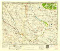
~ Minot ND topo map, 1:250000 scale, 1 X 2 Degree, Historical, 1958, updated 1958
Minot, North Dakota, USGS topographic map dated 1958.
Includes geographic coordinates (latitude and longitude). This topographic map is suitable for hiking, camping, and exploring, or framing it as a wall map.
Printed on-demand using high resolution imagery, on heavy weight and acid free paper, or alternatively on a variety of synthetic materials.
Topos available on paper, Waterproof, Poly, or Tyvek. Usually shipping rolled, unless combined with other folded maps in one order.
- Product Number: USGS-5473785
- Free digital map download (high-resolution, GeoPDF): Minot, North Dakota (file size: 17 MB)
- Map Size: please refer to the dimensions of the GeoPDF map above
- Weight (paper map): ca. 55 grams
- Map Type: POD USGS Topographic Map
- Map Series: HTMC
- Map Verison: Historical
- Cell ID: 68913
- Scan ID: 285534
- Imprint Year: 1958
- Woodland Tint: Yes
- Field Check Year: 1954
- Datum: Unstated
- Map Projection: Transverse Mercator
- Map published by United States Geological Survey
- Map published by United States Army Corps of Engineers
- Map published by United States Army
- Map Language: English
- Scanner Resolution: 600 dpi
- Map Cell Name: Minot
- Grid size: 1 X 2 Degree
- Date on map: 1958
- Map Scale: 1:250000
- Geographical region: North Dakota, United States
Neighboring Maps:
All neighboring USGS topo maps are available for sale online at a variety of scales.
Spatial coverage:
Topo map Minot, North Dakota, covers the geographical area associated the following places:
- Bantry - Westhope - South Prairie - Sherwood - Ruthville - Gardena - East Dunseith - Omemee - Rangeley - Loraine - Ralston - Kuroki - Sawyer - Minot - Towner - Velva - Voltaire - Burlington - Forfar - Aurelia - Newburg - Cole Ford - Berthold - Des Lacs - Wolseth - Donnybrook - Fonda - Dunseith - Bergen - Berwick - Landa - Greene - Chola - Deering - Glenburn - Orrin - Logan - Leverich - Barton - Hartland - Tagus - Surrey - Karlsruhe - Carbury - Balta - Hurd - Lansford - Lonetree - Norma - Hesnault - Willow City - Foxholm - Plaza - Kelvin - Dunning - Renville - Eckman - Granville - Denbigh - Kramer - Drady - Russell - Truro - Carpio - Simcoe - Antler - Rising - San Haven - Tasco - Tunbridge - Maxbass - Milroy - White - Belmar - Riga - Bottineau - Tolley - Mohall - Verendrye - Guthrie - Norwich - Roth - Upham - Overly - Souris - Grano - Genoa
- Map Area ID: AREA4948-102-100
- Northwest corner Lat/Long code: USGSNW49-102
- Northeast corner Lat/Long code: USGSNE49-100
- Southwest corner Lat/Long code: USGSSW48-102
- Southeast corner Lat/Long code: USGSSE48-100
- Northern map edge Latitude: 49
- Southern map edge Latitude: 48
- Western map edge Longitude: -102
- Eastern map edge Longitude: -100


