
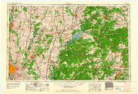
~ Tulsa OK topo map, 1:250000 scale, 1 X 2 Degree, Historical, 1963
Tulsa, Oklahoma, USGS topographic map dated 1963.
Includes geographic coordinates (latitude and longitude). This topographic map is suitable for hiking, camping, and exploring, or framing it as a wall map.
Printed on-demand using high resolution imagery, on heavy weight and acid free paper, or alternatively on a variety of synthetic materials.
Topos available on paper, Waterproof, Poly, or Tyvek. Usually shipping rolled, unless combined with other folded maps in one order.
- Product Number: USGS-5473193
- Free digital map download (high-resolution, GeoPDF): Tulsa, Oklahoma (file size: 16 MB)
- Map Size: please refer to the dimensions of the GeoPDF map above
- Weight (paper map): ca. 55 grams
- Map Type: POD USGS Topographic Map
- Map Series: HTMC
- Map Verison: Historical
- Cell ID: 69064
- Scan ID: 801068
- Woodland Tint: Yes
- Aerial Photo Year: 1958
- Datum: Unstated
- Map Projection: Transverse Mercator
- Map published by United States Geological Survey
- Map Language: English
- Scanner Resolution: 508 dpi
- Map Cell Name: Tulsa
- Grid size: 1 X 2 Degree
- Date on map: 1963
- Map Scale: 1:250000
- Geographical region: Oklahoma, United States
Neighboring Maps:
All neighboring USGS topo maps are available for sale online at a variety of scales.
Spatial coverage:
Topo map Tulsa, Oklahoma, covers the geographical area associated the following places:
- Healing Springs - Chance - Commerce - Bella Vista - Hoover (historical) - Lynn Lane - Barbara (historical) - Puckett (historical) - Sunsweet - Woods (historical) - McElhany - Elliott - Westview - Riverside Inn - Ogeechee - Mills (historical) - Tiawah - Line Store (historical) - Summit (historical) - Rhea - Lowell - Center Point - Bozarth (historical) - Sulphur Springs - Martin - Flint (historical) - Rome City (historical) - Rogers - Alluwe - Teresita - Leetown - Ellerville - Wentworth - Ottawa - Keetonville - Foyil - Crag O Lea - Highfill - Copan - Chelsea - Mazie - Pioneer - Enterprise (historical) - Bartlesville - Steele - Shady Grove - Ionia - Gentry - Logan - Elba - Bethlehem - Kansas - Harmony Star - Oak Grove - Bull Hollow - Dewey - Banzet - Yonkers - Potter (historical) - Bethel Heights - Nowata - Jay - Deep Ford - Sonora - McNatt - Pedro - Childers - Powell - Spurgeon - Rago - Hoot Owl - Verdigris - Pyramid Corners - Noel - West Seneca - Murphy - Old Eucha - Newtonia - Griffin Ford - Coodys Bluff - Jaybird (historical) - Goodman - Pensacola - Baldwin - Buttry (historical) - Afton - Mason Valley - Ballou - Sweetwater - Splitlog - Twin Springs - Sunrise - Viney Grove - Erie - Lowrey - Bluejacket - Peoria - Seneca - Monte Ne - Elliff
- Map Area ID: AREA3736-96-94
- Northwest corner Lat/Long code: USGSNW37-96
- Northeast corner Lat/Long code: USGSNE37-94
- Southwest corner Lat/Long code: USGSSW36-96
- Southeast corner Lat/Long code: USGSSE36-94
- Northern map edge Latitude: 37
- Southern map edge Latitude: 36
- Western map edge Longitude: -96
- Eastern map edge Longitude: -94


