
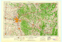
~ Oklahoma City OK topo map, 1:250000 scale, 1 X 2 Degree, Historical, 1963
Oklahoma City, Oklahoma, USGS topographic map dated 1963.
Includes geographic coordinates (latitude and longitude). This topographic map is suitable for hiking, camping, and exploring, or framing it as a wall map.
Printed on-demand using high resolution imagery, on heavy weight and acid free paper, or alternatively on a variety of synthetic materials.
Topos available on paper, Waterproof, Poly, or Tyvek. Usually shipping rolled, unless combined with other folded maps in one order.
- Product Number: USGS-5473185
- Free digital map download (high-resolution, GeoPDF): Oklahoma City, Oklahoma (file size: 17 MB)
- Map Size: please refer to the dimensions of the GeoPDF map above
- Weight (paper map): ca. 55 grams
- Map Type: POD USGS Topographic Map
- Map Series: HTMC
- Map Verison: Historical
- Cell ID: 68947
- Scan ID: 802352
- Woodland Tint: Yes
- Field Check Year: 1957
- Datum: Unstated
- Map Projection: Transverse Mercator
- Map published by United States Army Corps of Engineers
- Map published by United States Army
- Map Language: English
- Scanner Resolution: 508 dpi
- Map Cell Name: Oklahoma City
- Grid size: 1 X 2 Degree
- Date on map: 1963
- Map Scale: 1:250000
- Geographical region: Oklahoma, United States
Neighboring Maps:
All neighboring USGS topo maps are available for sale online at a variety of scales.
Spatial coverage:
Topo map Oklahoma City, Oklahoma, covers the geographical area associated the following places:
- Garden Grove - Fallis - Kiefer - Eason - Cole - Butner - Valley Brook - Trousdale - Wandel - Forest Park - Haydenville - Bethany - Goodnight - Cimarron City - McLoud - Weleetka - Sacred Heart - Wheatland - Laden - Bristow - Amber - Paden - Jacktown - Edmond - Powers - Moore - Warwick - Richland - Willow View - Kingfisher - Tabor - Minco - Morvin - Bethel Acres - Boley - Union City - Cross Roads - Sapulpa - Mounds - Midway - Glenpool - Bearden - Clearview - Harjo - Choctaw - Wolf - Cedar Valley - Dale - Milfay - Seward - Lawrie - Fowler - Castle - Oriental - Shamrock - Gaddy - Wilzetta - Chandler - Tribbey - Meeker - The Village - Nichols Hills - Indogco - Little - Noble - Saint Louis - McKiddyville - Gypsy - Beggs - Woodlawn Park - Mason - Iron Post - Pink - Bowlegs - Morse - Iconium - Chilesville - Wetumka - Franklin - Del City - Lamar - Neal - Slaughterville - Stroud - Waterloo - Lillard Park - Macomb - Spencer - Brooksville - Sooner - Dixon - Dibble - Anderson - Hibsaw - Jones - Maud - Wellston - Spring Hill - Needmore - Econtuchka
- Map Area ID: AREA3635-98-96
- Northwest corner Lat/Long code: USGSNW36-98
- Northeast corner Lat/Long code: USGSNE36-96
- Southwest corner Lat/Long code: USGSSW35-98
- Southeast corner Lat/Long code: USGSSE35-96
- Northern map edge Latitude: 36
- Southern map edge Latitude: 35
- Western map edge Longitude: -98
- Eastern map edge Longitude: -96


