
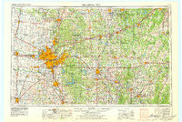
~ Oklahoma City OK topo map, 1:250000 scale, 1 X 2 Degree, Historical, 1957, updated 1979
Oklahoma City, Oklahoma, USGS topographic map dated 1957.
Includes geographic coordinates (latitude and longitude). This topographic map is suitable for hiking, camping, and exploring, or framing it as a wall map.
Printed on-demand using high resolution imagery, on heavy weight and acid free paper, or alternatively on a variety of synthetic materials.
Topos available on paper, Waterproof, Poly, or Tyvek. Usually shipping rolled, unless combined with other folded maps in one order.
- Product Number: USGS-5473183
- Free digital map download (high-resolution, GeoPDF): Oklahoma City, Oklahoma (file size: 16 MB)
- Map Size: please refer to the dimensions of the GeoPDF map above
- Weight (paper map): ca. 55 grams
- Map Type: POD USGS Topographic Map
- Map Series: HTMC
- Map Verison: Historical
- Cell ID: 68947
- Scan ID: 802351
- Imprint Year: 1979
- Woodland Tint: Yes
- Aerial Photo Year: 1976
- Edit Year: 1978
- Field Check Year: 1957
- Datum: Unstated
- Map Projection: Transverse Mercator
- Map published by United States Geological Survey
- Map Language: English
- Scanner Resolution: 508 dpi
- Map Cell Name: Oklahoma City
- Grid size: 1 X 2 Degree
- Date on map: 1957
- Map Scale: 1:250000
- Geographical region: Oklahoma, United States
Neighboring Maps:
All neighboring USGS topo maps are available for sale online at a variety of scales.
Spatial coverage:
Topo map Oklahoma City, Oklahoma, covers the geographical area associated the following places:
- Keokuk Falls - Cross Roads - Saint Louis - Clarks Heights - Pink - Arcadia - Smith Village - Ingram - Dustin - Earlsboro - Crescent - Soonerville - Vinco - Dixon - Milfay - Woodard Corner - Choctaw - Anderson - Newby - Nichols Hills - Aron - Shamrock - Edmond - Eason - Davenport - Willow View - Jones - Wildhorse - Clothier - Noble - Wetumka - Chilesville - Carson - Cimarron City - Laden - McLoud - Bearden - Midwest City - Pocasset - Mason - Indian Springs - Union City - Denver - Kiefer - Woods - Shawnee - Emsey - Oklahoma City - Norman - Johnson - Wilzetta - Brooksville - Dover - Britton - Guthrie - Lake Aluma - Gaddy - Bristow - Little Axe - Moore - Cashion - Etowah - Needmore - Horntown - Aydelotte - Welty - Coyle - Goodnight - Forest Park - Harrah - The Village - Fowler - Chisney - Poole - Lakeview - Stroud - Harjo - Powers - Waterloo - Boley - Beggs - Wandel - Maud - Newcastle - Twin Lakes - Wilson - Blanchard - Glenpool - Heyburn - Sac and Fox Agency (historical) - Woodlawn Park - Zion (historical) - Seminole - Wellston - Belmont Farms - Green Pastures - Bethel Acres - Dentonville - Amber - McKiddyville
- Map Area ID: AREA3635-98-96
- Northwest corner Lat/Long code: USGSNW36-98
- Northeast corner Lat/Long code: USGSNE36-96
- Southwest corner Lat/Long code: USGSSW35-98
- Southeast corner Lat/Long code: USGSSE35-96
- Northern map edge Latitude: 36
- Southern map edge Latitude: 35
- Western map edge Longitude: -98
- Eastern map edge Longitude: -96


