
~ Oklahoma City OK topo map, 1:250000 scale, 1 X 2 Degree, Historical, 1957, updated 1969
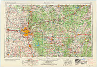
Oklahoma City, Oklahoma, USGS topographic map dated 1957.
Includes geographic coordinates (latitude and longitude). This topographic map is suitable for hiking, camping, and exploring, or framing it as a wall map.
Printed on-demand using high resolution imagery, on heavy weight and acid free paper, or alternatively on a variety of synthetic materials.
Topos available on paper, Waterproof, Poly, or Tyvek. Usually shipping rolled, unless combined with other folded maps in one order.
- Product Number: USGS-5473179
- Free digital map download (high-resolution, GeoPDF): Oklahoma City, Oklahoma (file size: 14 MB)
- Map Size: please refer to the dimensions of the GeoPDF map above
- Weight (paper map): ca. 55 grams
- Map Type: POD USGS Topographic Map
- Map Series: HTMC
- Map Verison: Historical
- Cell ID: 68947
- Scan ID: 800960
- Imprint Year: 1969
- Woodland Tint: Yes
- Edit Year: 1968
- Field Check Year: 1957
- Datum: Unstated
- Map Projection: Transverse Mercator
- Map published by United States Geological Survey
- Map Language: English
- Scanner Resolution: 508 dpi
- Map Cell Name: Oklahoma City
- Grid size: 1 X 2 Degree
- Date on map: 1957
- Map Scale: 1:250000
- Geographical region: Oklahoma, United States
Neighboring Maps:
All neighboring USGS topo maps are available for sale online at a variety of scales.
Spatial coverage:
Topo map Oklahoma City, Oklahoma, covers the geographical area associated the following places:
- Ellaville - Harjo - Centerview - Paden - Tabler - Wilzetta - Gypsy - Zion (historical) - Brooksville - Etowah - Middleberg - Bellvue - Blanchard - Macomb - Morvin - Burnett - Dunjee Park - Micawber - McKiddyville - Kendrick - Cimarron City - Shamrock - Woods - Drakes Corner - Bristow - Lake Aluma - Tabor - Dixon - Midway Village - Britton - Kingfisher - Indogco - Sac and Fox Agency (historical) - Purcell - Willow View - Newalla - Warwick - Crescent - Yukon - Neal - Cedar Valley - Cromwell - Amber - Depew - Arlington - Iron Post - Del City - Wilson - Avoca - Avery - Pulaski - IXL - Chandler - Lake Hiwassee - Butner - Forest Park - Spaulding - Econtuchka - Cottingham - Langston - Ingram - Laden - Bryant - Sacred Heart - Meeker - Heyburn - Wetumka - Weleetka - Frost - Newcastle - Anderson - Merrick - Macomb-Y - Cashion - Okfuskee - Emsey - Wellston - Edmond - Dale - Coyle - Clearview - Stella - Shiloh - Pearson - Denver - Banner - Little - Flynn - Prague - Keokuk Falls - El Reno - Payson - Nobletown - Midlothian - Aydelotte - Eason - Sapulpa - Watkins - Minco - Pleasant Grove
- Map Area ID: AREA3635-98-96
- Northwest corner Lat/Long code: USGSNW36-98
- Northeast corner Lat/Long code: USGSNE36-96
- Southwest corner Lat/Long code: USGSSW35-98
- Southeast corner Lat/Long code: USGSSE35-96
- Northern map edge Latitude: 36
- Southern map edge Latitude: 35
- Western map edge Longitude: -98
- Eastern map edge Longitude: -96


