
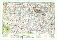
~ Lawton OK topo map, 1:250000 scale, 1 X 2 Degree, Historical, 1955, updated 1986
Lawton, Oklahoma, USGS topographic map dated 1955.
Includes geographic coordinates (latitude and longitude). This topographic map is suitable for hiking, camping, and exploring, or framing it as a wall map.
Printed on-demand using high resolution imagery, on heavy weight and acid free paper, or alternatively on a variety of synthetic materials.
Topos available on paper, Waterproof, Poly, or Tyvek. Usually shipping rolled, unless combined with other folded maps in one order.
- Product Number: USGS-5473171
- Free digital map download (high-resolution, GeoPDF): Lawton, Oklahoma (file size: 15 MB)
- Map Size: please refer to the dimensions of the GeoPDF map above
- Weight (paper map): ca. 55 grams
- Map Type: POD USGS Topographic Map
- Map Series: HTMC
- Map Verison: Historical
- Cell ID: 74964
- Scan ID: 802672
- Imprint Year: 1986
- Woodland Tint: Yes
- Aerial Photo Year: 1973
- Edit Year: 1974
- Field Check Year: 1955
- Datum: Unstated
- Map Projection: Transverse Mercator
- Map published by United States Geological Survey
- Map Language: English
- Scanner Resolution: 508 dpi
- Map Cell Name: Lawton
- Grid size: 1 X 2 Degree
- Date on map: 1955
- Map Scale: 1:250000
- Geographical region: Oklahoma, United States
Neighboring Maps:
All neighboring USGS topo maps are available for sale online at a variety of scales.
Spatial coverage:
Topo map Lawton, Oklahoma, covers the geographical area associated the following places:
- Grandfield - Acme (historical) - Randlett - Snyder - Loveland - Hooper - Grenade Crossing - Oil City - Byers - Medicine Park - Creata - Coxs Corner - Alden - Green Meadow Acres - Haynesville - Margaret - Rayland - Denton - Odell - Oklaunion - Vinson - Lincoln - The Holy City - Walters - Olustee - Tipton - Lawton - Sneed Acres - Humphreys - Hollister - Cold Springs - Nellie - Vernon - Reed - Irving - Bethel - Acme - Electra - Petrolia - Clara - Wheatland - Sandy - Broxton - Fivemile Corner - Eldorado - Lockett - Rocky Ford - Duhringe Pass - Porter Hill - Arnett - Centerville - Warren - Charlie - Thrift - Burt - Fletcher - Taylor - Indiahoma - Friendship - Harrold - Vivian - Chatto Crossing - Carl - Granite - Mangum - Corral Crossing - McKnight - Marty - Duke - Russell - Headrick - Parsley Hill - Punkin Center - Hess - Mountain Park - Willowview - Cooperton - Williams - Davidson - Chattanooga - Svoboda - Lake Ellsworth Addition - Welon - Laverty - Artillery Village - Hightower - Prairie Hill - Farwell - Hulen - Stecker - Ridley - Cyril - Hatchetville - Martha - Goodlett - Farmers Valley - Lige - Kiowa and Commanche Agency (historical) - Medicine Mound - Letitia
- Map Area ID: AREA3534-100-98
- Northwest corner Lat/Long code: USGSNW35-100
- Northeast corner Lat/Long code: USGSNE35-98
- Southwest corner Lat/Long code: USGSSW34-100
- Southeast corner Lat/Long code: USGSSE34-98
- Northern map edge Latitude: 35
- Southern map edge Latitude: 34
- Western map edge Longitude: -100
- Eastern map edge Longitude: -98


