
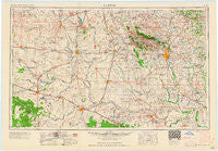
~ Lawton OK topo map, 1:250000 scale, 1 X 2 Degree, Historical, 1955, updated 1958
Lawton, Oklahoma, USGS topographic map dated 1955.
Includes geographic coordinates (latitude and longitude). This topographic map is suitable for hiking, camping, and exploring, or framing it as a wall map.
Printed on-demand using high resolution imagery, on heavy weight and acid free paper, or alternatively on a variety of synthetic materials.
Topos available on paper, Waterproof, Poly, or Tyvek. Usually shipping rolled, unless combined with other folded maps in one order.
- Product Number: USGS-5473169
- Free digital map download (high-resolution, GeoPDF): Lawton, Oklahoma (file size: 12 MB)
- Map Size: please refer to the dimensions of the GeoPDF map above
- Weight (paper map): ca. 55 grams
- Map Type: POD USGS Topographic Map
- Map Series: HTMC
- Map Verison: Historical
- Cell ID: 74964
- Scan ID: 800911
- Imprint Year: 1958
- Woodland Tint: Yes
- Field Check Year: 1955
- Datum: Unstated
- Map Projection: Transverse Mercator
- Map published by United States Geological Survey
- Map Language: English
- Scanner Resolution: 508 dpi
- Map Cell Name: Lawton
- Grid size: 1 X 2 Degree
- Date on map: 1955
- Map Scale: 1:250000
- Geographical region: Oklahoma, United States
Neighboring Maps:
All neighboring USGS topo maps are available for sale online at a variety of scales.
Spatial coverage:
Topo map Lawton, Oklahoma, covers the geographical area associated the following places:
- Artillery Village - Hulen - Carl - Lawton - Taylor Corner Gin - Olustee - Lazare - Humphreys - Elgin - Chillicothe - Byers - Willowview - Alden - Stecker - Victory - Indiahoma - Meers - Sedan - Peachtree Crossing - Duke - Carnes - Ridley - Faxon - Doans - Cooperton - Babbs - Grenade Crossing - Laverty - Shrewder - Letitia - Hess - Odell - Temple - Cookietown - Indiahoma Wye - Acme (historical) - Manitou - Walters - Lawtonka Acres - The Holy City - Mangum - Cove Acres - Prairie Hill - Welon - Roosevelt - Creta - Talbert Crossing - Irving - Medicine Park - Davidson - Thrift - Harrold - Grandfield - Taylor - Hollister - Fletcher - Cache - Frederick - Odetta - Cold Springs - Svoboda - Loveland - Lige - Acme - Lincoln - Ron - Lakeside Village - Cement - Mountain Park - Margaret - Lockett - Altus - Farwell - Clara - Four Mile Crossing - North Groesbeck - Apache - Martha - Hatchetville - Nellie - Elmer - Sandy - Vivian - Blair - Gas City - Burkburnett - Sterling - City View - Lake Ellsworth Addition - Fivemile Corner - Hinds - Randlett - Wheatland - Sneed Acres - Taupa - Oil City - Hester - Hollis - Hastings - Hooper
- Map Area ID: AREA3534-100-98
- Northwest corner Lat/Long code: USGSNW35-100
- Northeast corner Lat/Long code: USGSNE35-98
- Southwest corner Lat/Long code: USGSSW34-100
- Southeast corner Lat/Long code: USGSSE34-98
- Northern map edge Latitude: 35
- Southern map edge Latitude: 34
- Western map edge Longitude: -100
- Eastern map edge Longitude: -98


