
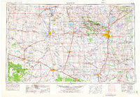
~ Lawton OK topo map, 1:250000 scale, 1 X 2 Degree, Historical, 1955, updated 1976
Lawton, Oklahoma, USGS topographic map dated 1955.
Includes geographic coordinates (latitude and longitude). This topographic map is suitable for hiking, camping, and exploring, or framing it as a wall map.
Printed on-demand using high resolution imagery, on heavy weight and acid free paper, or alternatively on a variety of synthetic materials.
Topos available on paper, Waterproof, Poly, or Tyvek. Usually shipping rolled, unless combined with other folded maps in one order.
- Product Number: USGS-5473165
- Free digital map download (high-resolution, GeoPDF): Lawton, Oklahoma (file size: 14 MB)
- Map Size: please refer to the dimensions of the GeoPDF map above
- Weight (paper map): ca. 55 grams
- Map Type: POD USGS Topographic Map
- Map Series: HTMC
- Map Verison: Historical
- Cell ID: 74964
- Scan ID: 707441
- Imprint Year: 1976
- Woodland Tint: Yes
- Photo Revision Year: 1974
- Aerial Photo Year: 1973
- Edit Year: 1974
- Datum: Unstated
- Map Projection: Transverse Mercator
- Advance: Yes
- Map published by United States Geological Survey
- Map Language: English
- Scanner Resolution: 508 dpi
- Map Cell Name: Lawton
- Grid size: 1 X 2 Degree
- Date on map: 1955
- Map Scale: 1:250000
- Geographical region: Oklahoma, United States
Neighboring Maps:
All neighboring USGS topo maps are available for sale online at a variety of scales.
Spatial coverage:
Topo map Lawton, Oklahoma, covers the geographical area associated the following places:
- Farwell - Williams - Tolbert - Lake Ellsworth Addition - Artillery Village - Electra - Hollis - Corral Crossing - Elmer - Petrolia - Hester - Apache - Randlett - Haynesville - Cement - Fletcher - Rocky Ford - Grandfield - Reed - Hooper - Shrewder - Odell - Hess - Tipton - Cookietown - Ozark - Corum - Willowview - Laverty - Boone - Medicine Mound - Temple - Cache Wye - Blair - Goodlett - Vinson - Kiowa and Commanche Agency (historical) - Geronimo - Madge - Lazare - Prairie Hill - Cyril - Taupa - Louis - McKnight - Stecker - Broxton - Warren - Odetta - Centerville - Loveland - Harrold - Vernon - Victory - Martha - Lockett - Roosevelt - Babbs - Gas City - Friendship - Duke - Letitia - Oil City - Mount View - Parsley Hill - Empire City - Lawton - Denton - Middleburg - Elliott - Creata - Hatchetville - Sneed Acres - Byers - Clara - Quanah - Grenade Crossing - Peachtree Crossing - Talbert Crossing - Olustee - Fargo - Irving - Burkburnett - Ridley - Doans - Fivemile Corner - Headrick - Humphreys - Snyder - City View - Carnes - Carl - Walters - Taylor Corner Gin - Chattanooga - Rayland - Sterling - Wheatland - Lige - Creta
- Map Area ID: AREA3534-100-98
- Northwest corner Lat/Long code: USGSNW35-100
- Northeast corner Lat/Long code: USGSNE35-98
- Southwest corner Lat/Long code: USGSSW34-100
- Southeast corner Lat/Long code: USGSSE34-98
- Northern map edge Latitude: 35
- Southern map edge Latitude: 34
- Western map edge Longitude: -100
- Eastern map edge Longitude: -98


