
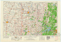
~ Enid OK topo map, 1:250000 scale, 1 X 2 Degree, Historical, 1955, updated 1966
Enid, Oklahoma, USGS topographic map dated 1955.
Includes geographic coordinates (latitude and longitude). This topographic map is suitable for hiking, camping, and exploring, or framing it as a wall map.
Printed on-demand using high resolution imagery, on heavy weight and acid free paper, or alternatively on a variety of synthetic materials.
Topos available on paper, Waterproof, Poly, or Tyvek. Usually shipping rolled, unless combined with other folded maps in one order.
- Product Number: USGS-5473161
- Free digital map download (high-resolution, GeoPDF): Enid, Oklahoma (file size: 13 MB)
- Map Size: please refer to the dimensions of the GeoPDF map above
- Weight (paper map): ca. 55 grams
- Map Type: POD USGS Topographic Map
- Map Series: HTMC
- Map Verison: Historical
- Cell ID: 68769
- Scan ID: 802250
- Imprint Year: 1966
- Woodland Tint: Yes
- Edit Year: 1965
- Field Check Year: 1955
- Datum: Unstated
- Map Projection: Transverse Mercator
- Map published by United States Geological Survey
- Map Language: English
- Scanner Resolution: 508 dpi
- Map Cell Name: Enid
- Grid size: 1 X 2 Degree
- Date on map: 1955
- Map Scale: 1:250000
- Geographical region: Oklahoma, United States
Neighboring Maps:
All neighboring USGS topo maps are available for sale online at a variety of scales.
Spatial coverage:
Topo map Enid, Oklahoma, covers the geographical area associated the following places:
- Maramec - Wes - Curchece - Fite - Casey - Roxana - Alcorn - Shea - Carbondale - Frankfort - Little Chief - Gray - Renfrow - Osage Junction - Grainola - Marland - Buffalo Springs Stage Station (historical) - Bigheart - Silver City - Rigsby - Nanos - Pearsonia - Gray Horse - Frey - Black Bear - Sumner - Callahan - Esau Junction - Pemeta - Carter Nine - West Tulsa - Leroy - Morgans Corner - West Point - Blackland - Apperson - Jefferson - Deer Creek - Wekiwa - Ralston - Pond Creek - Enid - Braman - Marena - Bison - Yale - Kaw City - Gibbon - Oakridge - Jacks - Medford - McMahon - New Mannford - Tonkawa - Avant - Nelagoney - Wolco - Opah - Mehan - Soldani - Prue - Webb City - Garber - Lone Chimney (historical) - North Enid - Imo - Nichols - Empy - Lake - Herd - Hallett - Oak Grove - Numa - Hayward - Midway - Prattville - Cropper - Sumpter - White Eagle - Cody - Osage - Strohm - Petes Corner - Glencoe - Quay - Lep - Gilbert - Gilland - Sha-To-She - Dilworth - Stillwater - Breckinridge - Lela - Gano - Skiatook - Otoe - Waukomis - Bills Corner - New Prue - Old Bliss
- Map Area ID: AREA3736-98-96
- Northwest corner Lat/Long code: USGSNW37-98
- Northeast corner Lat/Long code: USGSNE37-96
- Southwest corner Lat/Long code: USGSSW36-98
- Southeast corner Lat/Long code: USGSSE36-96
- Northern map edge Latitude: 37
- Southern map edge Latitude: 36
- Western map edge Longitude: -98
- Eastern map edge Longitude: -96


