
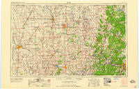
~ Enid OK topo map, 1:250000 scale, 1 X 2 Degree, Historical, 1958, updated 1958
Enid, Oklahoma, USGS topographic map dated 1958.
Includes geographic coordinates (latitude and longitude). This topographic map is suitable for hiking, camping, and exploring, or framing it as a wall map.
Printed on-demand using high resolution imagery, on heavy weight and acid free paper, or alternatively on a variety of synthetic materials.
Topos available on paper, Waterproof, Poly, or Tyvek. Usually shipping rolled, unless combined with other folded maps in one order.
- Product Number: USGS-5473155
- Free digital map download (high-resolution, GeoPDF): Enid, Oklahoma (file size: 14 MB)
- Map Size: please refer to the dimensions of the GeoPDF map above
- Weight (paper map): ca. 55 grams
- Map Type: POD USGS Topographic Map
- Map Series: HTMC
- Map Verison: Historical
- Cell ID: 68769
- Scan ID: 802247
- Imprint Year: 1958
- Woodland Tint: Yes
- Aerial Photo Year: 1954
- Field Check Year: 1955
- Datum: Unstated
- Map Projection: Transverse Mercator
- Map published by United States Army Corps of Engineers
- Map published by United States Army
- Map Language: English
- Scanner Resolution: 508 dpi
- Map Cell Name: Enid
- Grid size: 1 X 2 Degree
- Date on map: 1958
- Map Scale: 1:250000
- Geographical region: Oklahoma, United States
Neighboring Maps:
All neighboring USGS topo maps are available for sale online at a variety of scales.
Spatial coverage:
Topo map Enid, Oklahoma, covers the geographical area associated the following places:
- Fairmont - Lotsee - Whippoorwill - Cooper - Burbank - Olive - Blanton - Hardy - Wakita - Union - Webb City - Lela - Hayward - McCord - Glencoe - Bigheart - Pershing - Hominy - Jobes - Lucien - Masham - Cody - Osage Junction - Peckham - Esau Junction - Pemeta - Breckinridge - Shady Grove - Rigsby - McFadden Cove - Terlton - Blackland - Leroy - Hunter - Nichols - Nelagoney - Oak Ridge - Red Fork - Callahan - Morrison - Kengle - Timberlane - Lovell - Bowring - Covington - Middleton - Wekiwa - Gibbon - Baugh - Shirk - West Tulsa - Wes - Marena - Blackwell - Morgans Corner - Player - Curchece - Strohm - Rabornville - Eddy - Red Rock - Cedar Ridge - Billings - Opah - Boulangerville - Blackburn - Deer Creek - Fite - Newkirk - Lep - Skiatook - Hennessey - Waukomis - Lamont - Casey - Frankfort - Medford - Grainola - Mannford - Barnsdall - Wynona - Remington - Tonkawa - Calida - Apperson - Mulhall - Marland - Ceres - Gansel - North Enid - Woolaroc - Jubys - Uncas - Empy - Bison - New Mannford - Grainville - Watchorn - Soldani - Lake
- Map Area ID: AREA3736-98-96
- Northwest corner Lat/Long code: USGSNW37-98
- Northeast corner Lat/Long code: USGSNE37-96
- Southwest corner Lat/Long code: USGSSW36-98
- Southeast corner Lat/Long code: USGSSE36-96
- Northern map edge Latitude: 37
- Southern map edge Latitude: 36
- Western map edge Longitude: -98
- Eastern map edge Longitude: -96


