
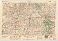
~ Clinton OK topo map, 1:250000 scale, 1 X 2 Degree, Historical, 1957
Clinton, Oklahoma, USGS topographic map dated 1957.
Includes geographic coordinates (latitude and longitude). This topographic map is suitable for hiking, camping, and exploring, or framing it as a wall map.
Printed on-demand using high resolution imagery, on heavy weight and acid free paper, or alternatively on a variety of synthetic materials.
Topos available on paper, Waterproof, Poly, or Tyvek. Usually shipping rolled, unless combined with other folded maps in one order.
- Product Number: USGS-5473149
- Free digital map download (high-resolution, GeoPDF): Clinton, Oklahoma (file size: 13 MB)
- Map Size: please refer to the dimensions of the GeoPDF map above
- Weight (paper map): ca. 55 grams
- Map Type: POD USGS Topographic Map
- Map Series: HTMC
- Map Verison: Historical
- Cell ID: 68721
- Scan ID: 802215
- Woodland Tint: Yes
- Field Check Year: 1955
- Datum: Unstated
- Map Projection: Transverse Mercator
- Map published by United States Army Corps of Engineers
- Map published by United States Army
- Map Language: English
- Scanner Resolution: 508 dpi
- Map Cell Name: Clinton
- Grid size: 1 X 2 Degree
- Date on map: 1957
- Map Scale: 1:250000
- Geographical region: Oklahoma, United States
Neighboring Maps:
All neighboring USGS topo maps are available for sale online at a variety of scales.
Spatial coverage:
Topo map Clinton, Oklahoma, covers the geographical area associated the following places:
- Mayfield - Burns Flat - Delhi - Carnegie - Swan Lake - Geary - Ioland (historical) - Mountain View - Dempsey - Oakwood - Corn - Jester - Anadarko - Arapaho - Rainy (historical) - Dutton - Bloomington - Omega - Sayre - Sentinel - Roll - Greenfield - Dead Women Crossing - Independence - Berlin - Hinton - Brinkman - Sweetwater - Watonga - Cordell - Hobart - Indianapolis - Hydro - Nowhere - Strong City - McClure - Prentiss - Erick - Elk City - Albert - Lookeba - Clinton - Cowden Junction - Thomas - Stafford - Retrop - Hext - Hammon - Carpenter - Indian City - Merritt - Dill City - Durham - Sickles - Butler - Willow - Osceola (historical) - Mackie - Altona - Port - Grimes - Braithwaite - Alpha - Cloud Chief - Squaretop - Colony - Burmah - Leedey - Lake Creek - Cody - Verden - Fay - Komalty - Nobscot - Leonel - Oneida - Canute - New Liberty - Cambridge - Reydon - Crawford - Aledo - Old Retrop - Trail - Sunset - Bessie - Carter - Cheyenne - Bridgeport - Indian Village (historical) - Moravia - Herring - Apache Wye - Eakly - Pine Ridge - Meridian - Ralph - Foss - Binger - Taylor
- Map Area ID: AREA3635-100-98
- Northwest corner Lat/Long code: USGSNW36-100
- Northeast corner Lat/Long code: USGSNE36-98
- Southwest corner Lat/Long code: USGSSW35-100
- Southeast corner Lat/Long code: USGSSE35-98
- Northern map edge Latitude: 36
- Southern map edge Latitude: 35
- Western map edge Longitude: -100
- Eastern map edge Longitude: -98


