
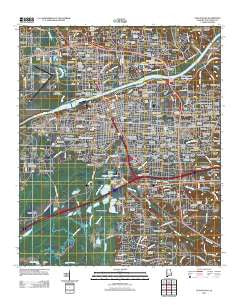
~ Tuscaloosa AL topo map, 1:24000 scale, 7.5 X 7.5 Minute, Historical, 2011
Tuscaloosa, Alabama, USGS topographic map dated 2011.
Includes geographic coordinates (latitude and longitude). This topographic map is suitable for hiking, camping, and exploring, or framing it as a wall map.
Printed on-demand using high resolution imagery, on heavy weight and acid free paper, or alternatively on a variety of synthetic materials.
Topos available on paper, Waterproof, Poly, or Tyvek. Usually shipping rolled, unless combined with other folded maps in one order.
- Product Number: USGS-5473137
- Free digital map download (high-resolution, GeoPDF): Tuscaloosa, Alabama (file size: 26 MB)
- Map Size: please refer to the dimensions of the GeoPDF map above
- Weight (paper map): ca. 55 grams
- Map Type: POD USGS Topographic Map
- Map Series: US Topo
- Map Verison: Historical
- Cell ID: 46031
- Datum: North American Datum of 1983
- Map Projection: Transverse Mercator
- Map Cell Name: Tuscaloosa
- Grid size: 7.5 X 7.5 Minute
- Date on map: 2011
- Map Scale: 1:24000
- Geographical region: Alabama, United States
Neighboring Maps:
All neighboring USGS topo maps are available for sale online at a variety of scales.
Spatial coverage:
Topo map Tuscaloosa, Alabama, covers the geographical area associated the following places:
- Parkview - Wood Ridge - Dearing Place - Meadow Lawn - Cherokee Hills - Alberta Heights - Vestavia Hills - Tuscaloosa - Princeton Place - Durrett Grove - Buena Vista - Forest Lake - Skyland Park - Greenbriar - Country Club Hills - Rollingwood - Heritage Hills - Parkwood - Crestmont - Brooksdale - Fox Run - Rivermont - Roselawn - Academy Drive - Pearson Subdivision - Cedar Crest - Fairlawn - Covey Chase - Bar Wayne Circle - West Circle - Dutton Place - Lakeview - Deven Dale - Princeton Heights - The Glens - Brookhaven - West Haven - Lincoln Park - The Highlands - Pine Hills - Burks Garden - Kings Acres - Riverside Circle - Mimosa Highlands - Lake Shore - Fernwood - The Downs - Meadowbrook - Fitts Heights - Guilds Woods - Taylor Circle - Oak Ridge - Harper Subdivision - High Forest - South Park - Oliver Heights - Taylorville - Skyland Manor - Lake Forest - Mimosa Manor - Arlington Mobile Home Park (historical) - Wood Villas - Stokes - Ingleside Village - Riverdale - University Lane - Buckhead - Riverchase - Crestview - Warrior Heights - Taylorwood Estates - Indian Lake - Snow Terrace - Circlewood - The Vineyards - Taylorville Heights - Sky Ranch - Livingston Subdivision - Riverview - Patton Place - Westridge - Cherry Dale - Greenview - Sommerville - Colonial Hills - Hickory Forest - Ridgeland - Kennedy Park - Manora Estates - Smith Acres - Brookmeade - Jerusalem Heights - East End - Forest Hills - Hollywood Park - Timberlane - Vestavia East - Green Hills - Gardendale - McKenzie Courts
- Map Area ID: AREA33.2533.125-87.625-87.5
- Northwest corner Lat/Long code: USGSNW33.25-87.625
- Northeast corner Lat/Long code: USGSNE33.25-87.5
- Southwest corner Lat/Long code: USGSSW33.125-87.625
- Southeast corner Lat/Long code: USGSSE33.125-87.5
- Northern map edge Latitude: 33.25
- Southern map edge Latitude: 33.125
- Western map edge Longitude: -87.625
- Eastern map edge Longitude: -87.5


