
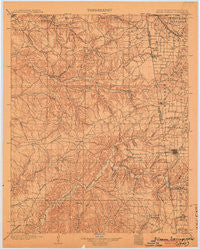
~ Siloam Springs OK topo map, 1:125000 scale, 30 X 30 Minute, Historical, 1904
Siloam Springs, Oklahoma, USGS topographic map dated 1904.
Includes geographic coordinates (latitude and longitude). This topographic map is suitable for hiking, camping, and exploring, or framing it as a wall map.
Printed on-demand using high resolution imagery, on heavy weight and acid free paper, or alternatively on a variety of synthetic materials.
Topos available on paper, Waterproof, Poly, or Tyvek. Usually shipping rolled, unless combined with other folded maps in one order.
- Product Number: USGS-5473051
- Free digital map download (high-resolution, GeoPDF): Siloam Springs, Oklahoma (file size: 6 MB)
- Map Size: please refer to the dimensions of the GeoPDF map above
- Weight (paper map): ca. 55 grams
- Map Type: POD USGS Topographic Map
- Map Series: HTMC
- Map Verison: Historical
- Cell ID: 66630
- Scan ID: 802593
- Survey Year: 1899
- Datum: Unstated
- Map Projection: Unstated
- Map published by United States Geological Survey
- Map Language: English
- Scanner Resolution: 508 dpi
- Map Cell Name: Siloam Springs
- Grid size: 30 X 30 Minute
- Date on map: 1904
- Map Scale: 1:125000
- Geographical region: Oklahoma, United States
Neighboring Maps:
All neighboring USGS topo maps are available for sale online at a variety of scales.
Spatial coverage:
Topo map Siloam Springs, Oklahoma, covers the geographical area associated the following places:
- Lowrey - Beckwith - Twin Oaks - Row - Chewey - Tagg Flats - Bozarth (historical) - Rome City (historical) - Colcord - Ionia - Rocky Ford - Siloam Springs - Flint - Moodys - Jay - Hico - Kenwood - Lake Frances - Chance - Checks Corner (historical) - Pactolus (historical) - Cincinnati - Eldorado Springs (historical) - West Siloam Springs - Bloomfield - Jaybird (historical) - Lee (historical) - Dripping Springs - Beaty - Bull Hollow - Wann (historical) - Cherokee City - Ballard - Cloud Creek - Ellerville - Eucha - Old Eucha - Flint Creek - Liberty - Crump (historical) - Leach - Twin Springs - West Point - Teresita - Kansas - Cave (historical) - Zena - Chloeta - Maysville - Scraper - Sycamore - Oaks - Miller Springs (historical) - Watts - Falling Springs - Brush Creek - Tonnece - Dawn Hill
- Map Area ID: AREA36.536-95-94.5
- Northwest corner Lat/Long code: USGSNW36.5-95
- Northeast corner Lat/Long code: USGSNE36.5-94.5
- Southwest corner Lat/Long code: USGSSW36-95
- Southeast corner Lat/Long code: USGSSE36-94.5
- Northern map edge Latitude: 36.5
- Southern map edge Latitude: 36
- Western map edge Longitude: -95
- Eastern map edge Longitude: -94.5


