
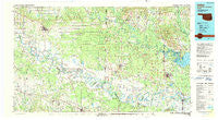
~ Idabel OK topo map, 1:100000 scale, 30 X 60 Minute, Historical, 1990, updated 1990
Idabel, Oklahoma, USGS topographic map dated 1990.
Includes geographic coordinates (latitude and longitude). This topographic map is suitable for hiking, camping, and exploring, or framing it as a wall map.
Printed on-demand using high resolution imagery, on heavy weight and acid free paper, or alternatively on a variety of synthetic materials.
Topos available on paper, Waterproof, Poly, or Tyvek. Usually shipping rolled, unless combined with other folded maps in one order.
- Product Number: USGS-5472755
- Free digital map download (high-resolution, GeoPDF): Idabel, Oklahoma (file size: 21 MB)
- Map Size: please refer to the dimensions of the GeoPDF map above
- Weight (paper map): ca. 55 grams
- Map Type: POD USGS Topographic Map
- Map Series: HTMC
- Map Verison: Historical
- Cell ID: 67698
- Scan ID: 707150
- Imprint Year: 1990
- Woodland Tint: Yes
- Aerial Photo Year: 1988
- Edit Year: 1990
- Datum: NAD27
- Map Projection: Universal Transverse Mercator
- Map published by United States Geological Survey
- Map Language: English
- Scanner Resolution: 508 dpi
- Map Cell Name: Idabel
- Grid size: 30 X 60 Minute
- Date on map: 1990
- Map Scale: 1:100000
- Geographical region: Oklahoma, United States
Neighboring Maps:
All neighboring USGS topo maps are available for sale online at a variety of scales.
Spatial coverage:
Topo map Idabel, Oklahoma, covers the geographical area associated the following places:
- Williamson - Tom - Reeds Settlement - Burns - Wilton - Holly Creek - Cornhill (historical) - Rocky Comfort - Goodlake - Peytonville - Lanesport - Paraclifta (historical) - Alleene - West Otis - Mistletoe (historical) - Redbank - Bokhoma - Arkinda - Caney - Redland - Cowlingsville - Eastport - Lukfata (historical) - Wades Chapel - Barkman - Wallace - Garvin - Ben Lomond - Wamba - Cross Roads - Hill Chapel - Rankin (historical) - Oak Grove - Beaverdam - Spanish Bluff (historical) - Red Bank - Oak Grove - Milford - Crossroads - Pennys - Annona - White Rock - Idabel - Comet - Long - Paraloma - Vessey - Pine Springs - Oak Grove - White Cliffs - Neal Springs - Thompson Subdivision - Pleasant Hill - Brownstown - Leidygate (historical) - Morris Ferry (historical) - Wade - Index - Smith Hill - De Kalb - Millers Crossing - Ogden - Richmond - Shults - Harris - Milrose - Jewell - Bellville - Eagle Town (historical) - Ashdown - Fomby - Shinewell - Jacks Isle - Stringtown - Lockesburg - Cerrogordo - Woodstock - Horatio - Yarborough Landing - English - Madras - Dilworth - Greenwood - Iron Stob Corner - Lippton (historical) - Walnut Springs - Moon - Goodwater - Kullituklo - Billingsleys Corner - Bryarly - Savannah (historical) - Pankov - Acworth - Avery - Pine Prairie - Haworth - Arden - Rosedale (historical) - Norwoodville
- Map Area ID: AREA3433.5-95-94
- Northwest corner Lat/Long code: USGSNW34-95
- Northeast corner Lat/Long code: USGSNE34-94
- Southwest corner Lat/Long code: USGSSW33.5-95
- Southeast corner Lat/Long code: USGSSE33.5-94
- Northern map edge Latitude: 34
- Southern map edge Latitude: 33.5
- Western map edge Longitude: -95
- Eastern map edge Longitude: -94


