
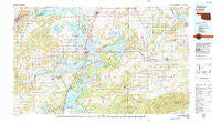
~ Eufaula OK topo map, 1:100000 scale, 30 X 60 Minute, Historical, 1978, updated 1979
Eufaula, Oklahoma, USGS topographic map dated 1978.
Includes geographic coordinates (latitude and longitude). This topographic map is suitable for hiking, camping, and exploring, or framing it as a wall map.
Printed on-demand using high resolution imagery, on heavy weight and acid free paper, or alternatively on a variety of synthetic materials.
Topos available on paper, Waterproof, Poly, or Tyvek. Usually shipping rolled, unless combined with other folded maps in one order.
- Product Number: USGS-5472743
- Free digital map download (high-resolution, GeoPDF): Eufaula, Oklahoma (file size: 24 MB)
- Map Size: please refer to the dimensions of the GeoPDF map above
- Weight (paper map): ca. 55 grams
- Map Type: POD USGS Topographic Map
- Map Series: HTMC
- Map Verison: Historical
- Cell ID: 67488
- Scan ID: 707144
- Imprint Year: 1979
- Woodland Tint: Yes
- Aerial Photo Year: 1973
- Edit Year: 1978
- Datum: NAD27
- Map Projection: Universal Transverse Mercator
- Map published by United States Geological Survey
- Map Language: English
- Scanner Resolution: 508 dpi
- Map Cell Name: Eufaula
- Grid size: 30 X 60 Minute
- Date on map: 1978
- Map Scale: 1:100000
- Geographical region: Oklahoma, United States
Neighboring Maps:
All neighboring USGS topo maps are available for sale online at a variety of scales.
Spatial coverage:
Topo map Eufaula, Oklahoma, covers the geographical area associated the following places:
- Warner - Porum - Russellville - Reams - Bug Tussle - Bristow Point - Briartown - Pierce - Canadian - Crowder - Featherston - Blocker - Eufaula - Gulftown - Duchess Landing - Lenna - Hughart - Richardsville - Kusa - Hanna - Stidham - Lewisville - Brush Hill - Garland - Longtown - Canadian Fork - Indianola - Sans Bois - Vernon - Lequire - Sams Point - Shady Grove - Enterprise - Salem - Canadian Shores - Massey Point - Vivian - Lafayette - Scipio - Coalton - Spelter City - Mellette - Checotah - Stigler - Hoffman - Raiford - Mekko - Hoyt - Carlton Landing - Onapa - Dewar - Fame - Ulan - Simms - Whitefield - Sunrise - Texanna - Henryetta - Quinton - Kinta - Lodi - Dighton - Highway 9 Landing - Carters Corner
- Map Area ID: AREA35.535-96-95
- Northwest corner Lat/Long code: USGSNW35.5-96
- Northeast corner Lat/Long code: USGSNE35.5-95
- Southwest corner Lat/Long code: USGSSW35-96
- Southeast corner Lat/Long code: USGSSE35-95
- Northern map edge Latitude: 35.5
- Southern map edge Latitude: 35
- Western map edge Longitude: -96
- Eastern map edge Longitude: -95


