
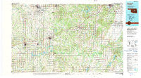
~ Bristow OK topo map, 1:100000 scale, 30 X 60 Minute, Historical, 1990, updated 1990
Bristow, Oklahoma, USGS topographic map dated 1990.
Includes geographic coordinates (latitude and longitude). This topographic map is suitable for hiking, camping, and exploring, or framing it as a wall map.
Printed on-demand using high resolution imagery, on heavy weight and acid free paper, or alternatively on a variety of synthetic materials.
Topos available on paper, Waterproof, Poly, or Tyvek. Usually shipping rolled, unless combined with other folded maps in one order.
- Product Number: USGS-5472731
- Free digital map download (high-resolution, GeoPDF): Bristow, Oklahoma (file size: 27 MB)
- Map Size: please refer to the dimensions of the GeoPDF map above
- Weight (paper map): ca. 55 grams
- Map Type: POD USGS Topographic Map
- Map Series: HTMC
- Map Verison: Historical
- Cell ID: 67186
- Scan ID: 707138
- Imprint Year: 1990
- Woodland Tint: Yes
- Aerial Photo Year: 1980
- Edit Year: 1990
- Datum: NAD27
- Map Projection: Universal Transverse Mercator
- Map published by United States Geological Survey
- Map Language: English
- Scanner Resolution: 508 dpi
- Map Cell Name: Bristow
- Grid size: 30 X 60 Minute
- Date on map: 1990
- Map Scale: 1:100000
- Geographical region: Oklahoma, United States
Neighboring Maps:
All neighboring USGS topo maps are available for sale online at a variety of scales.
Spatial coverage:
Topo map Bristow, Oklahoma, covers the geographical area associated the following places:
- Paden - Edna - Welty - Chandler - Sapulpa - Park Wheeler Corner - Shamrock - Pulaski - Milfay - Morse - Kiefer - Tryon - Cottingham - Slick - Drumright - Payson - Ritts Junction - Arlington - Meeker - Last Chance - Newby - Sac and Fox Agency (historical) - Gypsy - Haydenville - Stroud - Avery - Midlothian - Mounds - Depew - Parkland - Iron Post - Wildhorse - Cushing - Woodard Corner - Chilesville - Bristow - Wilson - Aron - Watkins - Wilzetta - Kendrick - Glenpool - Heyburn - South Village - Anderson - Clifton - IXL - Rossville - Bellvue - Oriental - Midway - Sunrise - Sparks - Tuskegee - Tabor - Agra - North Village - Soonerville - Beggs - Micawber - Dentonville - Okfuskee - Mason - Nuyaka - Kellyville - Drakes Corner - Laden - Davenport
- Map Area ID: AREA3635.5-97-96
- Northwest corner Lat/Long code: USGSNW36-97
- Northeast corner Lat/Long code: USGSNE36-96
- Southwest corner Lat/Long code: USGSSW35.5-97
- Southeast corner Lat/Long code: USGSSE35.5-96
- Northern map edge Latitude: 36
- Southern map edge Latitude: 35.5
- Western map edge Longitude: -97
- Eastern map edge Longitude: -96


