
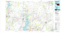
~ Bartlesville OK topo map, 1:100000 scale, 30 X 60 Minute, Historical, 1985, updated 1985
Bartlesville, Oklahoma, USGS topographic map dated 1985.
Includes geographic coordinates (latitude and longitude). This topographic map is suitable for hiking, camping, and exploring, or framing it as a wall map.
Printed on-demand using high resolution imagery, on heavy weight and acid free paper, or alternatively on a variety of synthetic materials.
Topos available on paper, Waterproof, Poly, or Tyvek. Usually shipping rolled, unless combined with other folded maps in one order.
- Product Number: USGS-5472723
- Free digital map download (high-resolution, GeoPDF): Bartlesville, Oklahoma (file size: 17 MB)
- Map Size: please refer to the dimensions of the GeoPDF map above
- Weight (paper map): ca. 55 grams
- Map Type: POD USGS Topographic Map
- Map Series: HTMC
- Map Verison: Historical
- Cell ID: 67098
- Scan ID: 707134
- Imprint Year: 1985
- Woodland Tint: Yes
- Aerial Photo Year: 1981
- Edit Year: 1985
- Datum: NAD27
- Map Projection: Universal Transverse Mercator
- Planimetric: Yes
- Map published by United States Geological Survey
- Map Language: English
- Scanner Resolution: 508 dpi
- Map Cell Name: Bartlesville
- Grid size: 30 X 60 Minute
- Date on map: 1985
- Map Scale: 1:100000
- Geographical region: Oklahoma, United States
Neighboring Maps:
All neighboring USGS topo maps are available for sale online at a variety of scales.
Spatial coverage:
Topo map Bartlesville, Oklahoma, covers the geographical area associated the following places:
- South Coffeyville - Talala - Lenapah - Estella - Big Cabin - Cocklebur Flat - Dewey - Pyramid Corners - Delaware - Vinita - Success - Rogers - Centralia - Watova - Banzet - Copan - Bartlesville - Hollow - Ketchum - White Oak - Nowata - Ramona - Bowlin Spring - Chelsea - Coodys Bluff - Owen - Cotton Valley - Ruthdale - Ochelata - Kelso - Cornatzar - Oglesby - Glenoak - Hogshooter - Elliott - Grand Lake Towne - Matoaka - Sanders - Okoee - Todd - Jamestown - Welch - Childers - Wann - Sunsweet - Owen - Alluwe - Winganon - Bluejacket - Catale - Noxie
- Map Area ID: AREA3736.5-96-95
- Northwest corner Lat/Long code: USGSNW37-96
- Northeast corner Lat/Long code: USGSNE37-95
- Southwest corner Lat/Long code: USGSSW36.5-96
- Southeast corner Lat/Long code: USGSSE36.5-95
- Northern map edge Latitude: 37
- Southern map edge Latitude: 36.5
- Western map edge Longitude: -96
- Eastern map edge Longitude: -95


