
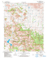
~ Saddle Mountain OK topo map, 1:24000 scale, 7.5 X 7.5 Minute, Historical, 1991, updated 1993
Saddle Mountain, Oklahoma, USGS topographic map dated 1991.
Includes geographic coordinates (latitude and longitude). This topographic map is suitable for hiking, camping, and exploring, or framing it as a wall map.
Printed on-demand using high resolution imagery, on heavy weight and acid free paper, or alternatively on a variety of synthetic materials.
Topos available on paper, Waterproof, Poly, or Tyvek. Usually shipping rolled, unless combined with other folded maps in one order.
- Product Number: USGS-5471403
- Free digital map download (high-resolution, GeoPDF): Saddle Mountain, Oklahoma (file size: 13 MB)
- Map Size: please refer to the dimensions of the GeoPDF map above
- Weight (paper map): ca. 55 grams
- Map Type: POD USGS Topographic Map
- Map Series: HTMC
- Map Verison: Historical
- Cell ID: 39143
- Scan ID: 706727
- Imprint Year: 1993
- Woodland Tint: Yes
- Aerial Photo Year: 1987
- Edit Year: 1991
- Field Check Year: 1988
- Datum: NAD27
- Map Projection: Lambert Conformal Conic
- Map published by United States Geological Survey
- Map Language: English
- Scanner Resolution: 508 dpi
- Map Cell Name: Saddle Mountain
- Grid size: 7.5 X 7.5 Minute
- Date on map: 1991
- Map Scale: 1:24000
- Geographical region: Oklahoma, United States
Neighboring Maps:
All neighboring USGS topo maps are available for sale online at a variety of scales.
Spatial coverage:
Topo map Saddle Mountain, Oklahoma, covers the geographical area associated the following places:
- Harrington Spring - Blue Mountain - Antelope Flat - Gray Wolf Spring - Moose Canyon - Antelope Flat - Hourigan Spring - Saddle Mountain - Grama Flat - Hobbs Canyon - Cedar Mountain - Kiowa Lake Dam - Geronimo Ridge - Oknoname 123006 Reservoir - Wichita Mountains Wildlife Refuge - Greenleaf Canyon - Gramma Lake - Comanche Lake Dam - Soldiers Dam - Elk Pass - Hollis Pond - Wichita Mountains Wilderness (North Mountain Unit) - Black Bear Spring - Grama Lake - Winter Valley - Medicine Tank - North Mountain - Moko Mountain - Turkey Pass - Whistle Peak - Township of Saddle Mountain - Pearl Mountain - Cold Spring - Spencer Creek - Gramma Lake Dam - Rain Gauge Flat - Saddle Mountain Indian Mission (historical) - Gray Wolf Crossing - Comanche Lake - Wichita Mountains - Saddle Mountain - North Mountain Wilderness - Oknoname 123006 Dam - Mount Lauramac - Saddle Mountain Fire Department - Kiowa Lake - Saddle Mountain Cemetery
- Map Area ID: AREA34.87534.75-98.75-98.625
- Northwest corner Lat/Long code: USGSNW34.875-98.75
- Northeast corner Lat/Long code: USGSNE34.875-98.625
- Southwest corner Lat/Long code: USGSSW34.75-98.75
- Southeast corner Lat/Long code: USGSSE34.75-98.625
- Northern map edge Latitude: 34.875
- Southern map edge Latitude: 34.75
- Western map edge Longitude: -98.75
- Eastern map edge Longitude: -98.625


