
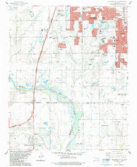
~ Oklahoma City SE OK topo map, 1:24000 scale, 7.5 X 7.5 Minute, Historical, 1986, updated 1986
Oklahoma City SE, Oklahoma, USGS topographic map dated 1986.
Includes geographic coordinates (latitude and longitude). This topographic map is suitable for hiking, camping, and exploring, or framing it as a wall map.
Printed on-demand using high resolution imagery, on heavy weight and acid free paper, or alternatively on a variety of synthetic materials.
Topos available on paper, Waterproof, Poly, or Tyvek. Usually shipping rolled, unless combined with other folded maps in one order.
- Product Number: USGS-5470919
- Free digital map download (high-resolution, GeoPDF): Oklahoma City SE, Oklahoma (file size: 10 MB)
- Map Size: please refer to the dimensions of the GeoPDF map above
- Weight (paper map): ca. 55 grams
- Map Type: POD USGS Topographic Map
- Map Series: HTMC
- Map Verison: Historical
- Cell ID: 33031
- Scan ID: 706498
- Imprint Year: 1986
- Woodland Tint: Yes
- Aerial Photo Year: 1984
- Edit Year: 1986
- Field Check Year: 1985
- Datum: NAD27
- Map Projection: Lambert Conformal Conic
- Map published by United States Geological Survey
- Map Language: English
- Scanner Resolution: 600 dpi
- Map Cell Name: Oklahoma City SE
- Grid size: 7.5 X 7.5 Minute
- Date on map: 1986
- Map Scale: 1:24000
- Geographical region: Oklahoma, United States
Neighboring Maps:
All neighboring USGS topo maps are available for sale online at a variety of scales.
Spatial coverage:
Topo map Oklahoma City SE, Oklahoma, covers the geographical area associated the following places:
- First Baptist Church - Calvary Brethren in Christ Church - Alliance Bible Church - Rock Assembly of God - Community Cupboard Church - Westmoore High School - Antioch Church - Shartel Church of God - Oklahoma City Fire Department Station 35 - Sky Ranch Elementary School - Appletree Square - Southpark Baptist Church - Capitol Hill Baptist Church South - Lightning Creek Holding Pond A Dam - Oklahoma Chinese Baptist Church - Saint Johns Lutheran Church - Oknoname 02728 Dam - Kingsview Freewill Baptist Church - Shadow Lake - Lightning Creek Holding Pond A - Church of God of Prophesy - Ten Mile Flat - WWLS-AM (Moore) - Kelly Elementary School - Oknoname 02728 Reservoir - Fisher Elementary School - Earlywine Park - Revival for Christ Club Incorporated Church - Moore Cemetery - Shadow Dam - Greenway Plaza - Emmaus Church - Southgate Baptist Church - Church of the Holy Apostles - Briarwood Elementary School - Southside Church - Southgate - Rippetoe Elementary School - Moore Fire Department Station 2 - Wayland Bonds Elementary School - Baptist Childrens Home - Oknoname 02732 Reservoir - Oknoname 02701 Reservoir - Saint Andrews Catholic Church - Newcastle Police Department - Oknoname 02731 Reservoir - Newcastle Fire Department Station 1 - Eastlake Elementary School - United Pentecostal Church - Oknoname 02702 Dam - Oknoname 02701 Dam - Oknoname 02731 Dam - West Junior High School - Westmore Baptist Church - Brink Junior High School - Meadowbrook School - Antioch Christian Academy - Oknoname 02732 Dam - Temple Baptist Church - Pleasant Valley School - Southmoore High School - The Church of Jesus Christ of Latter Day Saints - Emmanuel Cemetery - Kingspark Baptist Church - Kingsgate Elementary School - Santa Fe Elementary School - Houchin Elementary School - Capitol Hill Full Gospel Church - New Beginning Fellowship Church - Earlywine Elementary School - Holy Cross Lutheran Church - Red Oak Elementary School - Southwest Christian Academy - Odom's Roost Airport - Plaza Towers Elementary School - Lost Creek - Southwestern Plaza - Highland West Junior High School - Malibu Shopping Center - Kingdom Hall of Jehovahs Witnesses-Moore - Beth Haven Independent Baptist Church - Resthaven Gardens Cemetery - Township of Liberty - Regency Park Baptist Church - Sharon Baptist Church - Graceway Baptist Church - Saint Mark the Evangelist Church - Southgate Baptist Church - Tabernacle of Praise - Jesus Alive Evangelistic Church - Antioch Christian Church - Newcastle Middle School - Shekinah Fellowship Church - Heritage Burial Park - Township of Taylor - Oknoname 02702 Reservoir - Tri-City - Newcastle Elementary School - Good Shepherd Christian Church - Roosevelt Elementary School - High Praise Church
- Map Area ID: AREA35.37535.25-97.625-97.5
- Northwest corner Lat/Long code: USGSNW35.375-97.625
- Northeast corner Lat/Long code: USGSNE35.375-97.5
- Southwest corner Lat/Long code: USGSSW35.25-97.625
- Southeast corner Lat/Long code: USGSSE35.25-97.5
- Northern map edge Latitude: 35.375
- Southern map edge Latitude: 35.25
- Western map edge Longitude: -97.625
- Eastern map edge Longitude: -97.5


