
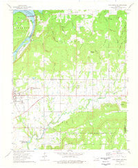
~ Fort Gibson Dam OK topo map, 1:24000 scale, 7.5 X 7.5 Minute, Historical, 1974, updated 1978
Fort Gibson Dam, Oklahoma, USGS topographic map dated 1974.
Includes geographic coordinates (latitude and longitude). This topographic map is suitable for hiking, camping, and exploring, or framing it as a wall map.
Printed on-demand using high resolution imagery, on heavy weight and acid free paper, or alternatively on a variety of synthetic materials.
Topos available on paper, Waterproof, Poly, or Tyvek. Usually shipping rolled, unless combined with other folded maps in one order.
- Product Number: USGS-5469651
- Free digital map download (high-resolution, GeoPDF): Fort Gibson Dam, Oklahoma (file size: 8 MB)
- Map Size: please refer to the dimensions of the GeoPDF map above
- Weight (paper map): ca. 55 grams
- Map Type: POD USGS Topographic Map
- Map Series: HTMC
- Map Verison: Historical
- Cell ID: 15908
- Scan ID: 705876
- Imprint Year: 1978
- Woodland Tint: Yes
- Aerial Photo Year: 1973
- Field Check Year: 1974
- Datum: NAD27
- Map Projection: Lambert Conformal Conic
- Map published by United States Geological Survey
- Map Language: English
- Scanner Resolution: 508 dpi
- Map Cell Name: Fort Gibson Dam
- Grid size: 7.5 X 7.5 Minute
- Date on map: 1974
- Map Scale: 1:24000
- Geographical region: Oklahoma, United States
Neighboring Maps:
All neighboring USGS topo maps are available for sale online at a variety of scales.
Spatial coverage:
Topo map Fort Gibson Dam, Oklahoma, covers the geographical area associated the following places:
- Canyon Road Public Use Area - Dripping Spring Hollow - Fourmile Branch - Iron Spring Hollow - Sleeper Hollow - Township of Nash - Fort Gibson Lake - Fort Gibson Early Learning Center - Blackberry Hill - Andersons Cemetery - Four Mile Cemetery - Runnels Mountain - Whiskey Hollow - Lucy Albirdie Flat - Norwood Fire Department Station 1 - Fort Gibson Citizen's Cemetery - Boughtman Hollow - Braggs Mountain - Deadman Hollow - Walker Cemetery - Hicks Branch - Cedar Hollow - Norwood Lakeview Church - Spurlop Mountain - Fourmile Branch Church - Fort Gibson Dam - Anderson Cemetery - Flower Creek - McGee Hollow - Starnes Cemetery - Walker Branch - Sugar Hollow - Fort Gibson Intermediate Elementary School - Norwood Elementary School - Kale Dick Hollow - Buzzard Hollow - Dam Site Public Use Area - Fourteenmile Creek - Fort Gibson National Cemetery - Fort Gibson Middle School - Fort Gibson High School - Limestone Hollow
- Map Area ID: AREA35.87535.75-95.25-95.125
- Northwest corner Lat/Long code: USGSNW35.875-95.25
- Northeast corner Lat/Long code: USGSNE35.875-95.125
- Southwest corner Lat/Long code: USGSSW35.75-95.25
- Southeast corner Lat/Long code: USGSSE35.75-95.125
- Northern map edge Latitude: 35.875
- Southern map edge Latitude: 35.75
- Western map edge Longitude: -95.25
- Eastern map edge Longitude: -95.125


