
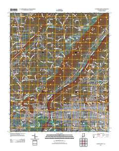
~ Gadsden West AL topo map, 1:24000 scale, 7.5 X 7.5 Minute, Historical, 2011
Gadsden West, Alabama, USGS topographic map dated 2011.
Includes geographic coordinates (latitude and longitude). This topographic map is suitable for hiking, camping, and exploring, or framing it as a wall map.
Printed on-demand using high resolution imagery, on heavy weight and acid free paper, or alternatively on a variety of synthetic materials.
Topos available on paper, Waterproof, Poly, or Tyvek. Usually shipping rolled, unless combined with other folded maps in one order.
- Product Number: USGS-5466335
- Free digital map download (high-resolution, GeoPDF): Gadsden West, Alabama (file size: 26 MB)
- Map Size: please refer to the dimensions of the GeoPDF map above
- Weight (paper map): ca. 55 grams
- Map Type: POD USGS Topographic Map
- Map Series: US Topo
- Map Verison: Historical
- Cell ID: 16626
- Datum: North American Datum of 1983
- Map Projection: Transverse Mercator
- Map Cell Name: Gadsden West
- Grid size: 7.5 X 7.5 Minute
- Date on map: 2011
- Map Scale: 1:24000
- Geographical region: Alabama, United States
Neighboring Maps:
All neighboring USGS topo maps are available for sale online at a variety of scales.
Spatial coverage:
Topo map Gadsden West, Alabama, covers the geographical area associated the following places:
- Walnut Park - Happy Hollow - Rhea (historical) - Ridgeville - Black Creek Falls (historical) - Stowers Hill - South Gadsden - The Highlands - Copeland Gap - Monte Vista - Maryville - Noble Hill - Attalla - Cave Springs - Scenic Heights - Curtiston - Gadsden - Reece City - Agricola - Moragne - Brans Chapel - Pleasant Hill - Lewin (historical) - Norton - Cox Gap - Alabama City - Bennettsville (historical) - Pull Tight (historical) - Crudup - Avery - Bellevue - Rockledge - Tuckahoe Heights - Morton (historical)
- Map Area ID: AREA34.12534-86.125-86
- Northwest corner Lat/Long code: USGSNW34.125-86.125
- Northeast corner Lat/Long code: USGSNE34.125-86
- Southwest corner Lat/Long code: USGSSW34-86.125
- Southeast corner Lat/Long code: USGSSE34-86
- Northern map edge Latitude: 34.125
- Southern map edge Latitude: 34
- Western map edge Longitude: -86.125
- Eastern map edge Longitude: -86


