
~ Leadbetter Island ME topo map, 1:24000 scale, 7.5 X 7.5 Minute, Historical, 2011
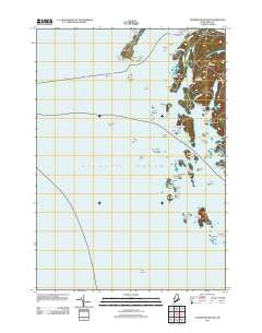
Leadbetter Island, Maine, USGS topographic map dated 2011.
Includes geographic coordinates (latitude and longitude). This topographic map is suitable for hiking, camping, and exploring, or framing it as a wall map.
Printed on-demand using high resolution imagery, on heavy weight and acid free paper, or alternatively on a variety of synthetic materials.
Topos available on paper, Waterproof, Poly, or Tyvek. Usually shipping rolled, unless combined with other folded maps in one order.
- Product Number: USGS-5465798
- Free digital map download (high-resolution, GeoPDF): Leadbetter Island, Maine (file size: 15 MB)
- Map Size: please refer to the dimensions of the GeoPDF map above
- Weight (paper map): ca. 55 grams
- Map Type: POD USGS Topographic Map
- Map Series: US Topo
- Map Verison: Historical
- Cell ID: 25217
- Datum: North American Datum of 1983
- Map Projection: Transverse Mercator
- Map Cell Name: Leadbetter Island
- Grid size: 7.5 X 7.5 Minute
- Date on map: 2011
- Map Scale: 1:24000
- Geographical region: Maine, United States
Neighboring Maps:
All neighboring USGS topo maps are available for sale online at a variety of scales.
Spatial coverage:
Topo map Leadbetter Island, Maine, covers the geographical area associated the following places:
- Tiptoe Mountain - Fox Ears - Pole Island - Clam Island - Leadbetter Island - Dogfish Island - Outward Bound School - Green Ledge - Seal Ledge - Lawrys Island - Middle Mountain - Browns Head - Conway Point - Fiddler Ledge - Little Hurricane Island - Fox Rocks - Long Cove - Youngs Cove - Ohio Island - Leadbetter Narrows - James and Willies Ledge - Crockett Cove - Rasberry Island - Dogfish Ledges - Narrow Place Beach - Hurricane Sound - Young Point - Big White Island - Dyer Pond - Lawrys Narrows - Dyer Island - Crabtree Point Ledge - Medric Rock - Drunkard Ledge - Hall Island - Lawrys Ledge - Harbor Island - Clam Ledge - Hurricane Island - Crotch Island - Little White Island - Crabtree Point - Crane Island - Big Garden Island - Spectacle Island - Cross Island Ledge - Crockett Point - Perry Ledge - Carver Ledge - Fish Head - Fiddlers Ledge - Deadman Ledge - South Big Garden Island - Stand-in Point - Gundell Island - Flat Island - Cedar Island - Fiddlehead Island - Browns Head Light Station - Garden Island - Calderwood Rock - Sand-in-Point Ledge - Sugar Loaves - Dog Fish Beacon - Turnip Island - White Island - Inner Bay Ledges - Green Island
- Map Area ID: AREA44.12544-69-68.875
- Northwest corner Lat/Long code: USGSNW44.125-69
- Northeast corner Lat/Long code: USGSNE44.125-68.875
- Southwest corner Lat/Long code: USGSSW44-69
- Southeast corner Lat/Long code: USGSSE44-68.875
- Northern map edge Latitude: 44.125
- Southern map edge Latitude: 44
- Western map edge Longitude: -69
- Eastern map edge Longitude: -68.875


