
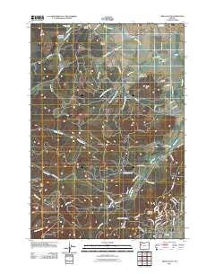
~ Airlie South OR topo map, 1:24000 scale, 7.5 X 7.5 Minute, Historical, 2011
Airlie South, Oregon, USGS topographic map dated 2011.
Includes geographic coordinates (latitude and longitude). This topographic map is suitable for hiking, camping, and exploring, or framing it as a wall map.
Printed on-demand using high resolution imagery, on heavy weight and acid free paper, or alternatively on a variety of synthetic materials.
Topos available on paper, Waterproof, Poly, or Tyvek. Usually shipping rolled, unless combined with other folded maps in one order.
- Product Number: USGS-5464219
- Free digital map download (high-resolution, GeoPDF): Airlie South, Oregon (file size: 23 MB)
- Map Size: please refer to the dimensions of the GeoPDF map above
- Weight (paper map): ca. 55 grams
- Map Type: POD USGS Topographic Map
- Map Series: US Topo
- Map Verison: Historical
- Cell ID: 312
- Datum: North American Datum of 1983
- Map Projection: Transverse Mercator
- Map Cell Name: Airlie South
- Grid size: 7.5 X 7.5 Minute
- Date on map: 2011
- Map Scale: 1:24000
- Geographical region: Oregon, United States
Neighboring Maps:
All neighboring USGS topo maps are available for sale online at a variety of scales.
Spatial coverage:
Topo map Airlie South, Oregon, covers the geographical area associated the following places:
- Johnson Reservoir - KHPE-FM - KLOO-FM - Cardwell Hills - KOAC-TV - Oak Hill - Adair Tract State Forest - North Fork Berry Creek - Baker Creek - Soap Creek School (historical) - Fuller Creek - Bald Hill City Park - Pride Peak - South Fork Berry Creek - Crescent Valley - Middle Fork Berry Creek - Staats Hollow - Williams Cemetery - Vineyard Mountain - Forest Peak - Kenney Reservoir - Sulphur Springs - Adair Rural Fire Protection District Station 1402 - Kester Pond - Peterson Creek - Spring Branch - Writsman Brook - KRKT-FM - Smith Hill - Lewisburg Saddle - McDonald State Forest - Corvallis Fire Department Station 6 - Staats Creek - Oakshire Reservoir
- Map Area ID: AREA44.7544.625-123.375-123.25
- Northwest corner Lat/Long code: USGSNW44.75-123.375
- Northeast corner Lat/Long code: USGSNE44.75-123.25
- Southwest corner Lat/Long code: USGSSW44.625-123.375
- Southeast corner Lat/Long code: USGSSE44.625-123.25
- Northern map edge Latitude: 44.75
- Southern map edge Latitude: 44.625
- Western map edge Longitude: -123.375
- Eastern map edge Longitude: -123.25


