
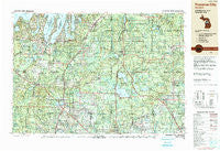
~ Traverse City MI topo map, 1:250000 scale, 1 X 2 Degree, Historical, 1989, updated 1990
Traverse City, Michigan, USGS topographic map dated 1989.
Includes geographic coordinates (latitude and longitude). This topographic map is suitable for hiking, camping, and exploring, or framing it as a wall map.
Printed on-demand using high resolution imagery, on heavy weight and acid free paper, or alternatively on a variety of synthetic materials.
Topos available on paper, Waterproof, Poly, or Tyvek. Usually shipping rolled, unless combined with other folded maps in one order.
- Product Number: USGS-5443794
- Free digital map download (high-resolution, GeoPDF): Traverse City, Michigan (file size: 24 MB)
- Map Size: please refer to the dimensions of the GeoPDF map above
- Weight (paper map): ca. 55 grams
- Map Type: POD USGS Topographic Map
- Map Series: HTMC
- Map Verison: Historical
- Cell ID: 69058
- Scan ID: 278776
- Imprint Year: 1990
- Woodland Tint: Yes
- Edit Year: 1989
- Datum: NAD83
- Map Projection: Universal Transverse Mercator
- Map published by United States Geological Survey
- Map Language: English
- Scanner Resolution: 600 dpi
- Map Cell Name: Traverse City
- Grid size: 1 X 2 Degree
- Date on map: 1989
- Map Scale: 1:250000
- Geographical region: Michigan, United States
Neighboring Maps:
All neighboring USGS topo maps are available for sale online at a variety of scales.
Spatial coverage:
Topo map Traverse City, Michigan, covers the geographical area associated the following places:
- West Branch - Lodi - Summit City - Northstar Mobile Home Park - Pheasant Ridge Estates Mobile Home Park - Butterfield - Grawn - Walton Junction - Barker Creek - Greilickville - Keswick - Platte River - Antrim - Fletcher - Country Village Estates Mobile Home Park - Oak Grove - Secord - Cutcheon - Sharon - Fairview - First Point Mobile Home Park - Heimforth - Sharps Corners - Harrison Mobile Home Estates - Taffeltown - Luther - Withi Trailer Park - Axin - Waters - O'Neil - Fountain Point - Mabel - Shady Lane Trailer Court - Bigelow - Angling - Schomberg - Cherrywood Village Mobile Home Park - Gilbert - McBain - Otsego Lake - Ogemaw Springs - Torch River - Lovells - Deward - Park Lake - Skidway Lake - Luzerne - Fivemile Corner - Star City - Maple Valley - Walton - Allendale - Dolph - Mancelona - Ash Acres - Sigma - Rasmus - Avondale - Sauble - South Boardman - Buck Trails - Harlan - Morres Junction - Meads Landing - Buckley - Mio - Meadow Lane Mobile Home Park - Darragh - Harrison - Pavlovic Corner - Pioneer - Five Corners - Artesia Beach - Au Sable River Park - Cotton - Lower Chub Landing - Louis Cabin Landing - Keelans Corner - Moddersville - Wagarville - Alba - Hannah - Johannesburg - Hobart - Alger - Cadillac - Cooperton - Bendon - Acme - Tustin - Skookum - Burdickville - Edwards - Arlene - Clam River - Highland - Fouch - Lewiston - Piney Woods - Leetsville
- Map Area ID: AREA4544-86-84
- Northwest corner Lat/Long code: USGSNW45-86
- Northeast corner Lat/Long code: USGSNE45-84
- Southwest corner Lat/Long code: USGSSW44-86
- Southeast corner Lat/Long code: USGSSE44-84
- Northern map edge Latitude: 45
- Southern map edge Latitude: 44
- Western map edge Longitude: -86
- Eastern map edge Longitude: -84


