
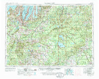
~ Traverse City MI topo map, 1:250000 scale, 1 X 2 Degree, Historical, 1954, updated 1986
Traverse City, Michigan, USGS topographic map dated 1954.
Includes geographic coordinates (latitude and longitude). This topographic map is suitable for hiking, camping, and exploring, or framing it as a wall map.
Printed on-demand using high resolution imagery, on heavy weight and acid free paper, or alternatively on a variety of synthetic materials.
Topos available on paper, Waterproof, Poly, or Tyvek. Usually shipping rolled, unless combined with other folded maps in one order.
- Product Number: USGS-5443792
- Free digital map download (high-resolution, GeoPDF): Traverse City, Michigan (file size: 24 MB)
- Map Size: please refer to the dimensions of the GeoPDF map above
- Weight (paper map): ca. 55 grams
- Map Type: POD USGS Topographic Map
- Map Series: HTMC
- Map Verison: Historical
- Cell ID: 69058
- Scan ID: 278775
- Imprint Year: 1986
- Woodland Tint: Yes
- Aerial Photo Year: 1953
- Field Check Year: 1954
- Datum: Unstated
- Map Projection: Transverse Mercator
- Map published by United States Geological Survey
- Map Language: English
- Scanner Resolution: 600 dpi
- Map Cell Name: Traverse City
- Grid size: 1 X 2 Degree
- Date on map: 1954
- Map Scale: 1:250000
- Geographical region: Michigan, United States
Neighboring Maps:
All neighboring USGS topo maps are available for sale online at a variety of scales.
Spatial coverage:
Topo map Traverse City, Michigan, covers the geographical area associated the following places:
- Wagarville - First Point Mobile Home Park - Lupton - Millers Corners - Deward - Johannesburg - Solon - Wildwood - Missaukee Junction - Karlin - Sherman - Sterling - McIntyre Landing - Garletts Corner - Campbells Corners - South Boardman - Leelanau Shores - Meauwataka - Withi Trailer Park - Denton Township Trailer Park - Hard Luck - Baxter - Wallin - Falmouth - Angel - Devils Elbow - Pere Cheney - Saint Helen - Bigelow - Dewing's (historical) - Glen Arbor - Suburban Estates Mobile Home Park - Ina - Wetzel - Dolph - King's Court Mobile Home Park - Green River - Copemish - Whites Landing - Bellaire - Log Haven Mobile Home Park - Michelson - Hillcrest - Star City - Peacock - Benson - Arbutus Beach - Heimforth - Antrim - Tustin - Taffeltown - Mapleton - Manton - Lower Chub Landing - Dublin - Glengary - Elbow Lake - Lake City - Pearll City - Shady Lane Trailer Court - Northstar Mobile Home Park - Axin - Bagnall - Babbits Resort - Sharon - Hobart - Boon - Rapid City - Eldorado - Morres Junction - Deibert - Haring - Highland - Artesia Beach - Suttons Bay - Melita - Elk Rapids - Frederic - Luther - Vienna Junction - Cherrywood Village Mobile Home Park - Kneeland - Nellsville - Avery - Bingham - Bucks - Alba - Dinca - Meredith - Hatchs - Country Village Estates Mobile Home Park - Mio - Temple - Bates - Birchwood Beach - Bodus - Butman - Vienna Corners - Port Oneida - Kewadin
- Map Area ID: AREA4544-86-84
- Northwest corner Lat/Long code: USGSNW45-86
- Northeast corner Lat/Long code: USGSNE45-84
- Southwest corner Lat/Long code: USGSSW44-86
- Southeast corner Lat/Long code: USGSSE44-84
- Northern map edge Latitude: 45
- Southern map edge Latitude: 44
- Western map edge Longitude: -86
- Eastern map edge Longitude: -84


