
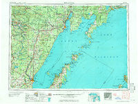
~ Escanaba MI topo map, 1:250000 scale, 1 X 2 Degree, Historical, 1958
Escanaba, Michigan, USGS topographic map dated 1958.
Includes geographic coordinates (latitude and longitude). This topographic map is suitable for hiking, camping, and exploring, or framing it as a wall map.
Printed on-demand using high resolution imagery, on heavy weight and acid free paper, or alternatively on a variety of synthetic materials.
Topos available on paper, Waterproof, Poly, or Tyvek. Usually shipping rolled, unless combined with other folded maps in one order.
- Product Number: USGS-5443714
- Free digital map download (high-resolution, GeoPDF): Escanaba, Michigan (file size: 18 MB)
- Map Size: please refer to the dimensions of the GeoPDF map above
- Weight (paper map): ca. 55 grams
- Map Type: POD USGS Topographic Map
- Map Series: HTMC
- Map Verison: Historical
- Cell ID: 68771
- Scan ID: 278728
- Woodland Tint: Yes
- Field Check Year: 1954
- Datum: Unstated
- Map Projection: Transverse Mercator
- Map published by United States Geological Survey
- Map Language: English
- Scanner Resolution: 600 dpi
- Map Cell Name: Escanaba
- Grid size: 1 X 2 Degree
- Date on map: 1958
- Map Scale: 1:250000
- Geographical region: Michigan, United States
Neighboring Maps:
All neighboring USGS topo maps are available for sale online at a variety of scales.
Spatial coverage:
Topo map Escanaba, Michigan, covers the geographical area associated the following places:
- Saint Jacques - Ford River - Cedar River - Birch Creek - Nahma Junction - Hardwood - Johnson Landing - Swanson - Hyde - Harris - Houle - Quinnesec - Garden - Rowleys Bay - Stonington - Daggett - Elkhorn - Spalding - Fairview Trailer Court - Cunard - Wells - Ossawinamakee Beach - Leapers - Kells - Rapid River - Stephenson - Salva - Detroit Harbor - North Escabana (historical) - Escanaba - Gardner - Pembine - Lake Bluff - Bayside Mobile Estates - North Escanaba - Sweetheart City - Wausaukee - Beaver - Peshtigo - Michiwaukee Shores - Gills Rock - Ogontz - Fairport - Masonville - Vega - Chandler - Brampton - Beecher Lake - Garden Corners - Soo Hill - Eustis - Narenta - Wagner - Norway - Packard - Island View - Bagley Junction - Maywood - Loretto - Groos - Middle Inlet - Gourley - Amberg - North Bay - West Gladstone - Carney - Menominee - Whitefish Hill RV and Mobile Home Park - Gulliver - Schaffer - Kremlin - Koss - Talbot - Devils Corner - Egg Harbor - Larch - Copenhagen Beach - Harmony - Washington - Hansen - Porterfield - Hannahville - Eagles Nest - Thompson - Bark River - Sunset Beach - Alton - Nathan - Kingsley - Helps - Maplewood - Saint Nicholas - Beecher - Foster City - Springer - LaBranche - Baileys Harbor - Wilson - Goll - Carbondale
- Map Area ID: AREA4645-88-86
- Northwest corner Lat/Long code: USGSNW46-88
- Northeast corner Lat/Long code: USGSNE46-86
- Southwest corner Lat/Long code: USGSSW45-88
- Southeast corner Lat/Long code: USGSSE45-86
- Northern map edge Latitude: 46
- Southern map edge Latitude: 45
- Western map edge Longitude: -88
- Eastern map edge Longitude: -86


