
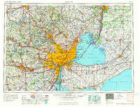
~ Detroit MI topo map, 1:250000 scale, 1 X 2 Degree, Historical, 1965
Detroit, Michigan, USGS topographic map dated 1965.
Includes geographic coordinates (latitude and longitude). This topographic map is suitable for hiking, camping, and exploring, or framing it as a wall map.
Printed on-demand using high resolution imagery, on heavy weight and acid free paper, or alternatively on a variety of synthetic materials.
Topos available on paper, Waterproof, Poly, or Tyvek. Usually shipping rolled, unless combined with other folded maps in one order.
- Product Number: USGS-5443710
- Free digital map download (high-resolution, GeoPDF): Detroit, Michigan (file size: 20 MB)
- Map Size: please refer to the dimensions of the GeoPDF map above
- Weight (paper map): ca. 55 grams
- Map Type: POD USGS Topographic Map
- Map Series: HTMC
- Map Verison: Historical
- Cell ID: 68747
- Scan ID: 278726
- Woodland Tint: Yes
- Field Check Year: 1961
- Datum: Unstated
- Map Projection: Transverse Mercator
- Map published by United States Geological Survey
- Map Language: English
- Scanner Resolution: 600 dpi
- Map Cell Name: Detroit
- Grid size: 1 X 2 Degree
- Date on map: 1965
- Map Scale: 1:250000
- Geographical region: Michigan, United States
Neighboring Maps:
All neighboring USGS topo maps are available for sale online at a variety of scales.
Spatial coverage:
Topo map Detroit, Michigan, covers the geographical area associated the following places:
- Pointe aux Chenes - College Heights Mobile Home Park - Grosse Ile - Beech - Oakley Park - Stark - Hartland - Lafayette Place Mobile Home Park - Sunnyside - Groveland Corners - Cone - Waltz - Emery - Warren Mobile Home Park - Allen's Trailer Court - Glengary - Eloise - Dover - Tecumseh - Oxford - Canton - Hi-Way Trailer Court - Avalon Beach - Muttonville - The Lakes Mobile Home Park - Ann Arbor - New Haven - Meade - Livonia - Chauteau Torrey Hills Mobile Home Park - Saline Meadows Mobile Home Park - Jerusalem - Clarkston - Clawson - Scio - Oak - Riverside - Richmond - New Hudson - Point Lakeview - Drayton Plains - Worden - Marine City - Pleasant Ridge - Superior - Geddes - Washington - Garden City - Wadhams - Saline Mobile Home Park - Edgewater Heights - Village Estates Mobile Home Park - Ford Boulevard Mobile Home Park - Westland - Yorkshire Manor Mobile Home Park - Delray - Estates of Genesee Valley Mobile Home Park - Hunters Creek - Carleton - Martindale Beach - Algonac - Clinton - Smiths Creek - Loon Lake Manufactured Home Community - Quakertown - Arbor Meadows Mobile Home Park - Denton - Union Lake - Snyderville - Conners Creek - Byron - Gibraltar - Saint Clair Haven - Lottivue - Sparlingville - Goodrich - Ideal Villa Mobile Home Park - Clinton - Fenton Oaks Mobile Home Community - Rawsonville - Rockwood - Grafton - South Rockwood - Seaway Mobile Home Ranch - Wyandotte - Taylor - Marysville Farms Manufacturing Home Community - Pearl Beach - Minnesota Lake Mobile Home Park - Saint Clair Place Mobile Home Park - Howell - Ferndale - French Town Villa Mobile Home Park - Newburg - River Rouge - Wolverine Lake - Dexter - Franklin - Rudgate Manor Mobile Home Park - Romulus
- Map Area ID: AREA4342-84-82
- Northwest corner Lat/Long code: USGSNW43-84
- Northeast corner Lat/Long code: USGSNE43-82
- Southwest corner Lat/Long code: USGSSW42-84
- Southeast corner Lat/Long code: USGSSE42-82
- Northern map edge Latitude: 43
- Southern map edge Latitude: 42
- Western map edge Longitude: -84
- Eastern map edge Longitude: -82


