
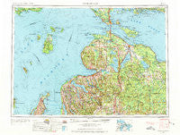
~ Cheboygan MI topo map, 1:250000 scale, 1 X 2 Degree, Historical, 1955, updated 1973
Cheboygan, Michigan, USGS topographic map dated 1955.
Includes geographic coordinates (latitude and longitude). This topographic map is suitable for hiking, camping, and exploring, or framing it as a wall map.
Printed on-demand using high resolution imagery, on heavy weight and acid free paper, or alternatively on a variety of synthetic materials.
Topos available on paper, Waterproof, Poly, or Tyvek. Usually shipping rolled, unless combined with other folded maps in one order.
- Product Number: USGS-5443694
- Free digital map download (high-resolution, GeoPDF): Cheboygan, Michigan (file size: 26 MB)
- Map Size: please refer to the dimensions of the GeoPDF map above
- Weight (paper map): ca. 55 grams
- Map Type: POD USGS Topographic Map
- Map Series: HTMC
- Map Verison: Historical
- Cell ID: 68713
- Scan ID: 278719
- Imprint Year: 1973
- Woodland Tint: Yes
- Visual Version Number: 2
- Edit Year: 1963
- Field Check Year: 1955
- Datum: Unstated
- Map Projection: Transverse Mercator
- Map published by United States Geological Survey
- Map Language: English
- Scanner Resolution: 600 dpi
- Map Cell Name: Cheboygan
- Grid size: 1 X 2 Degree
- Date on map: 1955
- Map Scale: 1:250000
- Geographical region: Michigan, United States
Neighboring Maps:
All neighboring USGS topo maps are available for sale online at a variety of scales.
Spatial coverage:
Topo map Cheboygan, Michigan, covers the geographical area associated the following places:
- Patons Corner - Lake Michigan Heights Mobile Home Park - Alanson - Elmhurst - Chippewa Beach - Saint James - Stutsmanville - Canfield Beach - Grand View - Huron Beach - Cheboygan - Van - Horton Bay - Radio City Village Mobile Home Park - Elmira - Alverno - Aloha - Creswell - British Landing - Northport - Charlevoix Estates - Snowflake (historical) - Port Dolomite - Royal Oak Beach - Grand View - Edgewater Beach - Grand View Beach - Cold Springs - Gros Cap - Indian River - Rainy Beach - Wauban Beach - Levering - Long Point - Freedom - Wequetonsing - Weadock - Lakeview Mobile Home Village - Bay Shore Estates - Mill Street Mobile Home Park - Nottingham Forest Mobile Home Park - Cedarville - Topinabee - Haakwood - Tower - Nomad - Wildwood - Saint Ignace - Giauque Beach - Leland - Onaway - Zenith Heights - Pointe Aux Pins - Mackinac Island - Manning - Veery Point - Gaylord - Hammond - Canby Corners - Aspen Commons Mobile Home Park - Cross Village - Miami Beach - Peshawbestown - Birchwood - Ahgosatown - Carp Lake - Ingleside - Ocqueoc - Ellsworth - Ironton - Boyne Falls - Grace - Pellston - Atlanta - Conway - Trowbridge - Marsh Corner - Menonaqua Beach - Town and Country Mobile Home Park - Boyne City - Allenville - Torch Lake - Burt Lake - Lake Terrace Mobile Court - Pittsburg Landing - Mackinaw Heights (historical) - High Banks - Harbor Point - Fingerboard Corner - Bliss - Pleasant Valley - Mullett Lake - Martins Bluff - Northside Community Mobile Home Park - Millersburg - Bonner Landing - Harbor Springs - East Jordan - Pine Grove Beach - Evergreen Shores
- Map Area ID: AREA4645-86-84
- Northwest corner Lat/Long code: USGSNW46-86
- Northeast corner Lat/Long code: USGSNE46-84
- Southwest corner Lat/Long code: USGSSW45-86
- Southeast corner Lat/Long code: USGSSE45-84
- Northern map edge Latitude: 46
- Southern map edge Latitude: 45
- Western map edge Longitude: -86
- Eastern map edge Longitude: -84


