
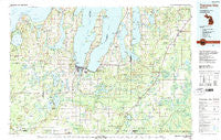
~ Traverse City MI topo map, 1:100000 scale, 30 X 60 Minute, Historical, 1983, updated 1984
Traverse City, Michigan, USGS topographic map dated 1983.
Includes geographic coordinates (latitude and longitude). This topographic map is suitable for hiking, camping, and exploring, or framing it as a wall map.
Printed on-demand using high resolution imagery, on heavy weight and acid free paper, or alternatively on a variety of synthetic materials.
Topos available on paper, Waterproof, Poly, or Tyvek. Usually shipping rolled, unless combined with other folded maps in one order.
- Product Number: USGS-5443674
- Free digital map download (high-resolution, GeoPDF): Traverse City, Michigan (file size: 28 MB)
- Map Size: please refer to the dimensions of the GeoPDF map above
- Weight (paper map): ca. 55 grams
- Map Type: POD USGS Topographic Map
- Map Series: HTMC
- Map Verison: Historical
- Cell ID: 68476
- Scan ID: 278705
- Imprint Year: 1984
- Woodland Tint: Yes
- Aerial Photo Year: 1981
- Edit Year: 1983
- Datum: NAD27
- Map Projection: Universal Transverse Mercator
- Map published by United States Geological Survey
- Map Language: English
- Scanner Resolution: 600 dpi
- Map Cell Name: Traverse City
- Grid size: 30 X 60 Minute
- Date on map: 1983
- Map Scale: 1:100000
- Geographical region: Michigan, United States
Neighboring Maps:
All neighboring USGS topo maps are available for sale online at a variety of scales.
Spatial coverage:
Topo map Traverse City, Michigan, covers the geographical area associated the following places:
- Solon - Chums Corner - Lake Ann - Bates - Maple City - Bendon - Platte River - Traverse City - Suttons Bay - Greilickville - Cotton - Mancelona - Meadow Lane Mobile Home Park - Kewadin - Mabel - Karlin - Acme - Torch River - Elk Rapids - Cedar - Leelanau Shores - Pavlovic Corner - Angling - Hannah - Hilltop - Jacks Landing - Schomberg - Angel - McGee - Deibert - Brookside - Lodi - Silver Shores Mobile Home Park - Isadore - Keswick - South Boardman - Bodus - Millers Corners - Barker Creek - Cherrywood Village Mobile Home Park - Taffeltown - Port Oneida - Crofton - Houseman - Suburban Estates Mobile Home Park - Cedar Run - Fife Lake - Grawn - Buckley - Darragh - Kalkaska - Bingham - Monroe Center - Leelanau Schools - Yuba - Cherry Bend - Leetsville - Mobile Home Estates - Rapid City - O'Neil - Green River - North Arms - Clam River - Cherryland Mobile Home Park - Woodcreek Mobile Home Park - Fouch - Williamsburg - Wetzel - McManus Corner - Old Mission - Hatchs - Sharon - Wexford Corner - Kingsley - Fountain Point - Glen Arbor - Interlochen - Mayfield - Heimforth - Spencer - Nessen City - Wallin - Devils Elbow - Silver Lake View Mobile Home Park - Burdickville - Sigma - Fivemile Corner - Northstar Mobile Home Park - Lake Leelanau - Westwood - Walton Junction - Town and Country Mobile Village - Giddings - Alden - Summit City - King's Court Mobile Home Park - Thompsonville - Crystal Spring - Antrim - Smithville
- Map Area ID: AREA4544.5-86-85
- Northwest corner Lat/Long code: USGSNW45-86
- Northeast corner Lat/Long code: USGSNE45-85
- Southwest corner Lat/Long code: USGSSW44.5-86
- Southeast corner Lat/Long code: USGSSE44.5-85
- Northern map edge Latitude: 45
- Southern map edge Latitude: 44.5
- Western map edge Longitude: -86
- Eastern map edge Longitude: -85


