
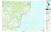
~ Tawas City MI topo map, 1:100000 scale, 30 X 60 Minute, Historical, 1984, updated 1991
Tawas City, Michigan, USGS topographic map dated 1984.
Includes geographic coordinates (latitude and longitude). This topographic map is suitable for hiking, camping, and exploring, or framing it as a wall map.
Printed on-demand using high resolution imagery, on heavy weight and acid free paper, or alternatively on a variety of synthetic materials.
Topos available on paper, Waterproof, Poly, or Tyvek. Usually shipping rolled, unless combined with other folded maps in one order.
- Product Number: USGS-5443668
- Free digital map download (high-resolution, GeoPDF): Tawas City, Michigan (file size: 29 MB)
- Map Size: please refer to the dimensions of the GeoPDF map above
- Weight (paper map): ca. 55 grams
- Map Type: POD USGS Topographic Map
- Map Series: HTMC
- Map Verison: Historical
- Cell ID: 68442
- Scan ID: 278700
- Imprint Year: 1991
- Woodland Tint: Yes
- Aerial Photo Year: 1982
- Edit Year: 1984
- Datum: NAD27
- Map Projection: Universal Transverse Mercator
- Map published by United States Geological Survey
- Map Language: English
- Scanner Resolution: 600 dpi
- Map Cell Name: Tawas City
- Grid size: 30 X 60 Minute
- Date on map: 1984
- Map Scale: 1:100000
- Geographical region: Michigan, United States
Neighboring Maps:
All neighboring USGS topo maps are available for sale online at a variety of scales.
Spatial coverage:
Topo map Tawas City, Michigan, covers the geographical area associated the following places:
- Hiawatha Trailer Park - Oak Wood Shores - South Branch - Long Lake - Hemlock - Prescott - Alabaster - Omer - McIvor - Turtle - Alabaster Junction - Arenac - Whittemore - Shady Shores - Delano - Sid Town - Twining - Lincoln Junction - Santiago - Huron Heights - Lake Huron Beach - Hale - Tawas River Trailer Park - Hyde Park - Oscoda - Whispering Woods Mobile Home Community - Wilber - Anderson Bayview - The Jackpines - Turner - Ausable Mobile Home Village - Benson Park - Whitestone Point - Foote Site Village - Knights Mill - Harmon City Heights - Glenwood Beach - Maple Ridge - Oscoda Mobile Home Park - National City - Au Gres - Birchwood Shores - White Rock - Meadow - Au Sable - Cedar Haven - Tawas City - Sand Lake - East Tawas - Clark Bayshore - Pine Wood Park - Port Crescent - Wagner Beach - Huron Oaks - Hammell Beach
- Map Area ID: AREA44.544-84-83
- Northwest corner Lat/Long code: USGSNW44.5-84
- Northeast corner Lat/Long code: USGSNE44.5-83
- Southwest corner Lat/Long code: USGSSW44-84
- Southeast corner Lat/Long code: USGSSE44-83
- Northern map edge Latitude: 44.5
- Southern map edge Latitude: 44
- Western map edge Longitude: -84
- Eastern map edge Longitude: -83


