
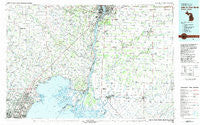
~ Lake St Clair North MI topo map, 1:100000 scale, 30 X 60 Minute, Historical, 1981, updated 1981
Lake St Clair North, Michigan, USGS topographic map dated 1981.
Includes geographic coordinates (latitude and longitude). This topographic map is suitable for hiking, camping, and exploring, or framing it as a wall map.
Printed on-demand using high resolution imagery, on heavy weight and acid free paper, or alternatively on a variety of synthetic materials.
Topos available on paper, Waterproof, Poly, or Tyvek. Usually shipping rolled, unless combined with other folded maps in one order.
- Product Number: USGS-5443616
- Free digital map download (high-resolution, GeoPDF): Lake St Clair North, Michigan (file size: 24 MB)
- Map Size: please refer to the dimensions of the GeoPDF map above
- Weight (paper map): ca. 55 grams
- Map Type: POD USGS Topographic Map
- Map Series: HTMC
- Map Verison: Historical
- Cell ID: 67802
- Scan ID: 278674
- Imprint Year: 1981
- Woodland Tint: Yes
- Aerial Photo Year: 1978
- Edit Year: 1981
- Datum: NAD27
- Map Projection: Universal Transverse Mercator
- Map published by United States Geological Survey
- Map Language: English
- Scanner Resolution: 600 dpi
- Map Cell Name: Lake Saint Clair North
- Grid size: 30 X 60 Minute
- Date on map: 1981
- Map Scale: 1:100000
- Geographical region: Michigan, United States
Neighboring Maps:
All neighboring USGS topo maps are available for sale online at a variety of scales.
Spatial coverage:
Topo map Lake St Clair North, Michigan, covers the geographical area associated the following places:
- Mount Clemens - Seaway Mobile Home Ranch - Kimball - Muttonville - Armada - Edison Mobile Home Court - Davis - Anchorville - Broadbridge Station - Rivers Edge a Quiet Community Mobile Home Park - Port of Call Mobile Home Park - Stock's Creek Mobile Home Park - Starville - Preston Corners - Tappan - Peters - Anchor Bay Shores - Pearl Beach - Saint Clair Place Mobile Home Park - Camelot Village Mobile Home Park - Riverside - Forster - Americana Estates Mobile Home Park - Sans Souci - Allenton - Smiths Creek - Richmond Place Mobile Home Estates - Anchor Bay Harbor - Wadhams - Wolcott Mills - Pointe aux Tremble - Marysville - Saint Clair - Chouteau Chesterfield Mobile Home Park - Berville - Muirs - Thornton - Memphis - Fraser - Algonac - Point Lakeview - Minnesota Lake Mobile Home Park - Martindale Beach - Goodells - Copeland Corner - Grande Pointe - Anchor Bay Gardens - Chesterfield - Richmond - Wales Center - West Tappan - Marysville Farms Manufacturing Home Community - Lakeside - South Park - Columbus - Sparlingville - Cady - Somerset Meadows Mobile Home Park - Emmett - Adair - Rattle Run - Ray Center - Fair Haven - Lambs - Lottivue - Casco - Saint Clair Haven - Bedore - Snyderville - Waldenburg - Chesterfield Shores - Port Huron - Sebille Manor - Cherry Beach - Maple Leaf - Clays Landing - Marysville Villa Estates Mobile Home Park - Riverbrook Mobile Home Park - Broad Acres - Milton - Riley Center - New Baltimore - Avalon Beach - Roberts Landing - Quail Run Community Mobile Home Park - Belle River - Hawthorne - Fenner's Mobile Village - Miller - Lesterville - Marine City - Meade - Tag-A-Long Trailer Court - Willow Point Mobile Home Park - Chouteau Estates Macomb Mobile Home Park - Macomb - New Haven - Perch Point - Pointe aux Chenes - Clinton
- Map Area ID: AREA4342.5-83-82
- Northwest corner Lat/Long code: USGSNW43-83
- Northeast corner Lat/Long code: USGSNE43-82
- Southwest corner Lat/Long code: USGSSW42.5-83
- Southeast corner Lat/Long code: USGSSE42.5-82
- Northern map edge Latitude: 43
- Southern map edge Latitude: 42.5
- Western map edge Longitude: -83
- Eastern map edge Longitude: -82


