
~ Hancock MI topo map, 1:100000 scale, 30 X 60 Minute, Historical, 1985, updated 1985
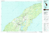
Hancock, Michigan, USGS topographic map dated 1985.
Includes geographic coordinates (latitude and longitude). This topographic map is suitable for hiking, camping, and exploring, or framing it as a wall map.
Printed on-demand using high resolution imagery, on heavy weight and acid free paper, or alternatively on a variety of synthetic materials.
Topos available on paper, Waterproof, Poly, or Tyvek. Usually shipping rolled, unless combined with other folded maps in one order.
- Product Number: USGS-5443592
- Free digital map download (high-resolution, GeoPDF): Hancock, Michigan (file size: 27 MB)
- Map Size: please refer to the dimensions of the GeoPDF map above
- Weight (paper map): ca. 55 grams
- Map Type: POD USGS Topographic Map
- Map Series: HTMC
- Map Verison: Historical
- Cell ID: 67629
- Scan ID: 278661
- Imprint Year: 1985
- Woodland Tint: Yes
- Aerial Photo Year: 1983
- Edit Year: 1985
- Datum: NAD27
- Map Projection: Universal Transverse Mercator
- Planimetric: Yes
- Map published by United States Geological Survey
- Map Language: English
- Scanner Resolution: 600 dpi
- Map Cell Name: Hancock
- Grid size: 30 X 60 Minute
- Date on map: 1985
- Map Scale: 1:100000
- Geographical region: Michigan, United States
Neighboring Maps:
All neighboring USGS topo maps are available for sale online at a variety of scales.
Spatial coverage:
Topo map Hancock, Michigan, covers the geographical area associated the following places:
- Seneca - Eagle Harbor - Eagle Nest - Phillipsville - Hancock - Kearsarge - Trimountain - Swedetown - Eagle River - Birch Grove Mobile Home Park - Atlantic Mine - Centennial Heights - Traverse Bay - Laurium - Osceola - Ahmeek - Freda - Pewabic - Houghton - Gregoryville - Dreamland - Traverse - Nepco Camp Number 7 - Redridge - Centennial - Snowshoe - Lac La Belle - West Tamarack - Franklin Mine - Mandan - Salmon Trout - Mohawk - Baltic - Wyoming - Hurontown - Dollar Bay - Beacon Hill - Delaware - Schmidt Corner - Rabbit Bay - Tamarack - Quincy Mill - Lake Linden - Hubbell - Hebards - Vaughnsville - Champion Mine - Superior - Oskar - Arcadian - Lewer Pewabic - Senter - Sunshine Beach - Pilgrim - Calumet - Chassell - Allouez - Gay - Copper Falls - Copper City - Bumbletown - Mill Mine Junction - Chassell Bay Cabins Mobile Home Park - Paavola - Liminga - Central - Lakeview - Fulton - Ripley - Phoenix - Mason - Painesdale - Dodgeville - South Range - Wolverine - Ojibway - Betsy - Boston - Point Mills
- Map Area ID: AREA47.547-89-88
- Northwest corner Lat/Long code: USGSNW47.5-89
- Northeast corner Lat/Long code: USGSNE47.5-88
- Southwest corner Lat/Long code: USGSSW47-89
- Southeast corner Lat/Long code: USGSSE47-88
- Northern map edge Latitude: 47.5
- Southern map edge Latitude: 47
- Western map edge Longitude: -89
- Eastern map edge Longitude: -88


