
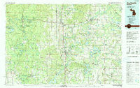
~ Big Rapids MI topo map, 1:100000 scale, 30 X 60 Minute, Historical, 1991, updated 1991
Big Rapids, Michigan, USGS topographic map dated 1991.
Includes geographic coordinates (latitude and longitude). This topographic map is suitable for hiking, camping, and exploring, or framing it as a wall map.
Printed on-demand using high resolution imagery, on heavy weight and acid free paper, or alternatively on a variety of synthetic materials.
Topos available on paper, Waterproof, Poly, or Tyvek. Usually shipping rolled, unless combined with other folded maps in one order.
- Product Number: USGS-5443540
- Free digital map download (high-resolution, GeoPDF): Big Rapids, Michigan (file size: 30 MB)
- Map Size: please refer to the dimensions of the GeoPDF map above
- Weight (paper map): ca. 55 grams
- Map Type: POD USGS Topographic Map
- Map Series: HTMC
- Map Verison: Historical
- Cell ID: 67133
- Scan ID: 278629
- Imprint Year: 1991
- Woodland Tint: Yes
- Aerial Photo Year: 1988
- Edit Year: 1991
- Datum: NAD27
- Map Projection: Universal Transverse Mercator
- Map published by United States Geological Survey
- Map Language: English
- Scanner Resolution: 600 dpi
- Map Cell Name: Big Rapids
- Grid size: 30 X 60 Minute
- Date on map: 1991
- Map Scale: 1:100000
- Geographical region: Michigan, United States
Neighboring Maps:
All neighboring USGS topo maps are available for sale online at a variety of scales.
Spatial coverage:
Topo map Big Rapids, Michigan, covers the geographical area associated the following places:
- Gibos Corners (historical) - Higbee Corner - Barryton - Big Prairie - Canadian Lakes - Olivers - Mecosta - Chippewa Vista - Jugville - Hunters Creek Estates Mobile Home Park - Stanwood - Ashton - Oxbow Park - Rustford - Woodland Park - Brohman - Forest Hills Mobile Home Park - Chippewa - Nirvana - Hawkins - Altona - Dayton Center - Lilley - Remus - Baldwin - Evart - Hersey - Slaybaugh Corner - Millbrook - Holiday Terrace Mobile Home Park - White Birch Estates Mobile Home Park - Chase - Lake - Chippewa Lake - Youngs Trailer Park - Idlewild - Country Mobile Home Park - Wooster - Broomfield Center - Huber - Halls Corner - Big Bend - Borland - Sherman City - Titus - Reed City - Big Rapids Mobile Home Court - Orono - Circle Drive Mobile Home Park - Alleyton (historical) - Ramona - White Cloud - Paris - Drew - Rodney - Havenview Mobile Home Court - Woodville - Horr - Blanchard - Bitely - Pogy - Big Rapids - Marlborough - Sylvester - Walgamor Corners - Grant Center - Aetna - Sears - College Park Mobile Village - Brinton - Pine Grove Beach
- Map Area ID: AREA4443.5-86-85
- Northwest corner Lat/Long code: USGSNW44-86
- Northeast corner Lat/Long code: USGSNE44-85
- Southwest corner Lat/Long code: USGSSW43.5-86
- Southeast corner Lat/Long code: USGSSE43.5-85
- Northern map edge Latitude: 44
- Southern map edge Latitude: 43.5
- Western map edge Longitude: -86
- Eastern map edge Longitude: -85


