
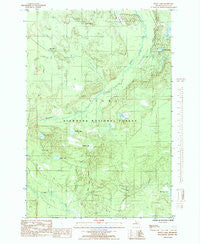
~ Waco Lake MI topo map, 1:24000 scale, 7.5 X 7.5 Minute, Historical, 1985, updated 1985
Waco Lake, Michigan, USGS topographic map dated 1985.
Includes geographic coordinates (latitude and longitude). This topographic map is suitable for hiking, camping, and exploring, or framing it as a wall map.
Printed on-demand using high resolution imagery, on heavy weight and acid free paper, or alternatively on a variety of synthetic materials.
Topos available on paper, Waterproof, Poly, or Tyvek. Usually shipping rolled, unless combined with other folded maps in one order.
- Product Number: USGS-5441518
- Free digital map download (high-resolution, GeoPDF): Waco Lake, Michigan (file size: 14 MB)
- Map Size: please refer to the dimensions of the GeoPDF map above
- Weight (paper map): ca. 55 grams
- Map Type: POD USGS Topographic Map
- Map Series: HTMC
- Map Verison: Historical
- Cell ID: 47085
- Scan ID: 277458
- Imprint Year: 1985
- Woodland Tint: Yes
- Aerial Photo Year: 1978
- Edit Year: 1985
- Field Check Year: 1982
- Datum: NAD27
- Map Projection: Universal Transverse Mercator
- Provisional map: Yes
- Map published by United States Geological Survey
- Map Language: English
- Scanner Resolution: 600 dpi
- Map Cell Name: Waco Lake
- Grid size: 7.5 X 7.5 Minute
- Date on map: 1985
- Map Scale: 1:24000
- Geographical region: Michigan, United States
Neighboring Maps:
All neighboring USGS topo maps are available for sale online at a variety of scales.
Spatial coverage:
Topo map Waco Lake, Michigan, covers the geographical area associated the following places:
- Plumbob Lake - Johnson Creek - Black Creek - Narbon Lake - Mink Creek - Billy Good Lake - Eighteenmile Creek - Gleason Lake - Camp Twentysix - Dana Lake - Polack Lake - Waco Lookout Tower - Waco Lake - Hiawatha National Forest - Kenobo Lake - Petoskey Hunting Club - Lakes Camp - Palos Camp
- Map Area ID: AREA46.12546-86.75-86.625
- Northwest corner Lat/Long code: USGSNW46.125-86.75
- Northeast corner Lat/Long code: USGSNE46.125-86.625
- Southwest corner Lat/Long code: USGSSW46-86.75
- Southeast corner Lat/Long code: USGSSE46-86.625
- Northern map edge Latitude: 46.125
- Southern map edge Latitude: 46
- Western map edge Longitude: -86.75
- Eastern map edge Longitude: -86.625


